

What Do You Mean By Transit Bearing?
Navigation, as we know, has been one of the most critical aspects of the maritime ambit since humankind started travelling around the world by waterways.
Once, sailors and seamen used celestial bodies to locate their position amidst the vast oceans and seas, and now modern-day technologies like GPS come in handy.
Similarly, navigation has also come a long way along with the advancement of technology and mechanisation across the globe.

The compass, one of humankind’s greatest inventions, gained prominence centuries back to the effect of citing its extensive usage in the seas. The simple device which gives us an idea about directionality using the earth’s magnetic field transpired as a significant improvement over the age-old methods of looking at celestial bodies.
Compasses were the most reliable means of navigation in ships for most of the 19th century, including the Titanic era of steamships and during the two World Wars.
However, they were gradually replaced by technologies like GPS and electronic charts in the latter half of the century. Nonetheless, notwithstanding all these technologies, compasses are still considered reliable modes of directionality. They are often used in emergencies when electronic systems fail.
What is a bearing?
In the terminology of navigations, bearing simply refers to the angle between an object of interest and a reference line. Thus, if we say that you are standing facing north and a house is situated exactly east of where you stand, it essentially means that the house has a clockwise angular bearing of 45 degrees with you.
Now, the bearing is of two types:
- Absolute
- Relative
The above example is a case of absolute bearing that is used when two objects are fixed.
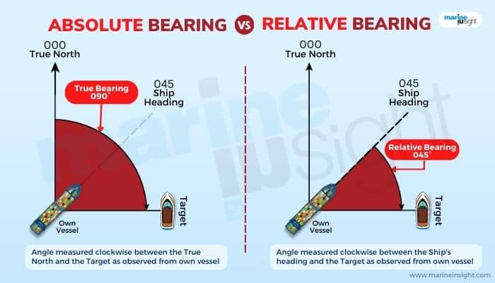
Relative bearing is used for moving bodies. In the above example, consider a rail rack that is situated at some distance southwards, that is behind where you stand. Consider a random person on a westbound train that is coming through those lines and sitting on the right side such that he is able to view the house from the compartment window when he crosses from here (and facing the train’s heading).
When the train is at a very large distance from your location, the house under consideration is at an angle of 0 degrees with respect to him. Now, when he approaches nearer, the bearing angle increases.
At the moment when the train is just crossing the house, the latter has a 45-degree relative bearing with respect to the observer. Now, when the train passes by but is still in the vicinity, the relative bearing of the house with respect to the observer continues increasing. When the train is again at a large distance from your location, the relative bearing saturates to 180 degrees.
Similarly, directionality from ships is an example of relative bearing. The location of any object with respect to the compass north is known as a compass bearing.
TRUE AND MAGNETIC DIRECTIONS AND COMPASS ERROR
We have some idea about magnetic and true directions. The true direction, like true north or true south, refers to the actual location with respect to the earth’s geographical coordinates.
With respect to the earth, the earth’s true or geographical north is the North Pole, and the geographical south is the South Pole. Thus, when we are at the Mexico border and looking northwards, the United States is at a true north or geographic. True directions are universally fixed.
What are magnetic directions?
These are dependent on the alignment of the earth’s magnetic field in the core. The earth’s magnetic field is not exactly aligned with the geographic directions but at an offset. Thus, the directions the needles of a classic compass point out are actually oriented as per the earth’s magnetic field; that is, north here essentially means magnetic north. The angular difference between the true direction and magnetic direction is known as the compass error.
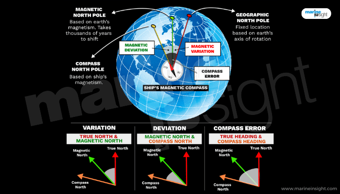
This is usually less and within a few degrees, depending on the configuration of the earth’s magnetic field. The earth’s magnetic north pole is somewhat westward of the North Pole and is presently located close to Ellesmere Island off Canada. Similarly, the earth’s magnetic south pole lies a bit off Antarctica’s mainland. The earth’s magnetic field is a dynamic phenomenon and shifts slightly over centuries.
One important thing to note here is that what we call the magnetic north pole is actually the magnetic south, and vice-versa! Because of the opposite polarity, the north dipole of a compass gets attracted towards the south and south towards the north. However, to avoid confusion, the direction towards which the compass needle points out is taken the same as the polarity of the compass.
When an object’s direction is measured with respect to the true north, the bearing is known as a true bearing. Similarly, when an object’s direction is measured with regard to magnetic north, it is known as a magnetic bearing.
In modern electronic compasses, the compass error is automatically rectified and the directions which we see on display are actually the true geographic directions. Hence, the directions that are shown on your smartphone compass app or the directions on Google Maps are true directions.
Similarly, in digital navigation systems of modern vessels, there is no space for errors. Furthermore, all modern vessels are equipped with electronic navigation charts that give correct geographical locations of objects true to accuracy and aided by GPS tracking systems relying on real-time digital satellite data.
TRANSIT BEARING
However, in olden times, when technology was still not much there, compass error was a crucial problem for seafarers and navigators. There were several ways devised to mitigate this. One of them was transit bearing.
Transit bearing was feasible when there were at least two fixed and visible objects in the vicinity of the ship. This could be two landmarks on a nearby shoreline, floating objects like buoys or even stationery vessels at a distance. These objects are said to be in transit. A line was then drawn through these objects and projected onto the navigation chart in the ship using a parallel ruler or other tools.
The angle between the line and the true geographical coordinates on the chart gave an idea of the true bearing of the objects.
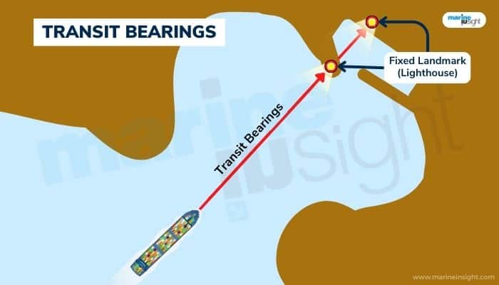
Then the vessel was aligned such that the heading was in line with those two objects. Thereafter, the compass bearing is noted.
The difference between the true and compass bearing gives an idea about the error.
As a rule, it was observed that when the compass bearing was higher than the true bearing, the error lied westwards, and when lesser than the true bearing, the error lay eastwards.
Hence, for example, if the compass bearing was 120 degrees and the true bearing was 117 degrees, the error of directionality is about 3 degrees westwards.
You Might Also Like To Read-
- Procedure for Cross Head Bearing Removal of Marine Engine – MAN B&W S50MC-C
- Procedure for Removing Main Bearing of MAN B&W MC-C Engine
- What is a Bearing Scraper?
- Understanding Turbocharger Bearings and Lubrication On Ships
Do you have info to share with us ? Suggest a correction

About Author
Subhodeep is a Naval Architecture and Ocean Engineering graduate. Interested in the intricacies of marine structures and goal-based design aspects, he is dedicated to sharing and propagation of common technical knowledge within this sector, which, at this very moment, requires a turnabout to flourish back to its old glory.


Latest Naval Arch Articles You Would Like:


Subscribe To Our Newsletters
By subscribing, you agree to our Privacy Policy and may receive occasional deal communications; you can unsubscribe anytime.