

What is Lowest Astronomical Tide?
In our previous articles, we extensively discussed the aspects of underwater keel clearance, grounding, and related effects like squatting. We had seen how while studying and estimating underwater keel clearance at a certain area, corrections related to tides are very crucial.
This is because, along with the time-varying hydrodynamics associated with water, the dynamic nature of the water levels is quite unpredictable. It depends on the geography, topography, weather effects like rainfall or heat, and of course, the effects of tides.
When the tides are at a high level, that is, the water level rises, the depth increases and any floating vessel will experience a greater margin with the seafloor, which is nothing but the underwater keel clearance or UKC. Conversely, when tidal levels fall, the underwater keel clearance gets reduced drastically, leading to risks of grounding and other problems.
Not only in the context of vessels and shipping but also for a litany of other reasons ranging from coastal engineering to fishing, oceanographic research to tourism and recreation, meteorological applications to day-to-day needs, an approximate estimation or idea about tidal levels is important.
Since, by nature, the exact estimation of the tidal level at a certain point in time is improbable, rough values are given by concerned bodies. Moreover, other than the levels, the times during which tidal levels rise and fall are also predicted.
As we all know, tides are the periodic rise and fall of water levels caused by the moon’s gravitational pull as well as the astronomical behaviour of the earth and neighbouring celestial bodies.
For all practical purposes, tides are essentially semi-diurnal in nature. A day when there is a spell of high tide or when there is an increase in the water levels is an instance of high tide.
Similarly, at another time, when there is a fall in the water levels or, in other words, the water ebbs away, there is a low tide.
This cycle is dependent on the rotation of the earth. Whichever side of the earth faces the moon, there will be high tide owing to the gravitational pull of the moon.
Conversely, all sides facing away from the moon shall experience low tide. The vertical difference between the high and low tides is known as the tidal range.
The tidal action is further affected by the sun as well. Twice a month, the sun, the earth and the moon are in a straight line. During those times, the combined effect of the sun and the moon is most pronounced.
Hence, the tidal levels reach the highest values and are known as spring tides. When the sun, moon, and earth are at right angles, the gravitational effects are most diminutive, and the tidal levels are much lower. These are known as neap tides.
Furthermore, tides, as we know, are dependent on various factors like meteorology, oceanographic phenomena, hydrodynamics, the geography of coasts and landmasses, climatic changes, atmospheric conditions, underwater topography, and so on.
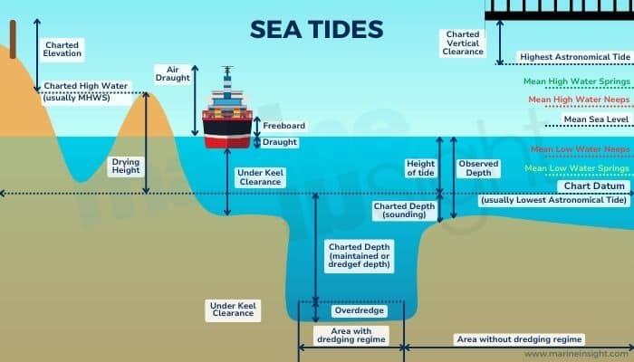
Now, before we discuss on Lowest Astronomical Tide (LAT), it is important to know what chart datums are or simply datums. For a range of purposes, as mentioned above, it is important to know water depths or levels.
Hence, for all practical purposes, it is important to have some kind of reference for estimation. For instance, when we say that a particular cliff on an island is at a height of X metres above sea level, it is always with reference to some sort of datum. Because the sea level there is continuously changing!
Similarly, when we say that the water depth at that location is H, we have two references, the water level at the top and the seafloor or seabed at the bottom, both of which are dynamic in nature.
Hence, based on various estimations, an average value of reference needs to be proposed. There are many kinds of reference levels that are used depending on the location, the application, the persisting condition, and any other specifications.
For instance, when there is a concern about navigation and underwater clearances, there are always the lowest values of datums are always taken into consideration as those are worst-case scenarios that can yield the least depths and, thus, the highest risks of grounding.
Hence, for all practical purposes, when the actual depths available are always more or less on the higher side, the vessels have an added margin of safety to minimise any risks of going aground.
Likewise, for example, during a coastal construction, all data pertaining to maximum values of tidal levels are taken into account as they would give an idea of worst-case conditions of high tides that need to be taken into consideration for the construction.
Speaking of depths and heights, all such datums are known as vertical datums. Lowest Astronomical Tide (LAT) is one such measure of a tidal level. By definition, it is the lowest predicted tide level that can occur at a location over a time period of 40 years.
As 40 years is a very long period of time in a meteorological and oceanographic timeline, the lowest predicted value of tides during this period is significantly low. However, one very important aspect of this tidal level is that this takes into account only the worst cases of astronomical conditions and NOT meteorological.
By astronomical, we mean only the effect of astronomical bodies like the Sun and Moon. As we discussed above, during the linear alignment of the Earth with the moon and sun, the tidal levels are very high. Similarly, during rare conditions like eclipses, the tidal fluctuations are highly variable and intense. LAT essentially takes into account every kind of astronomical extremity.
However, the Lowest Astronomical Tide does not take into account meteorological extremities. As we all know, climatic conditions highly influence water levels. They vary highly during climatic extremes like heavy monsoons, snow, heat waves, cyclones, hurricanes, storm surges, and so on.
With climate change now more fervent than ever, such conditions can only be expected to worsen. LAT essentially all such effects. It only takes into account average climatic conditions, including temperatures, more or less normal atmospheric conditions, barometric pressure, wind forces, normal currents, etc. Hence, if the ensuing meteorological conditions are extreme or fluctuating, there can be several occurrences of tidal levels lower than LAT.
LAT is essentially a predicted value that is estimated based on statistical data for nearly the last two decades (precisely 18.6 years). Along with recorded tidal observations, datasets used include reliable statistical and numerical models and data points based on oceanographic, astronomic, and meteorological data.
The time interval for reference is chosen as 18.6 as it is about the same time frame as a lunar nutation, which is a small change in the orientation of the moon’s axis of rotation over time, in simple terms.
One very important advantage of LAT is that they give absolute depth values in proper magnitudes. However, one disadvantage of LAT is that they often show discrepancies with other standard datum used.
Other commonly used standard datums used for reference are mean sea level, mean tide level, mean high water, mean low water, mean water spring, and so on. Some of them are predictive, like LAT, while some are recorded or computed.
The diametric opposite of LAT is the Highest Astronomical Tide or HAT. It is the maximum possible value of tides at a location over a span of 40 years under all permutations of astronomical extremities and under average meteorological conditions.
LAT and HAT are more or less satisfactory measure but has chances of losing reliability indices due to high variations worldwide owing to climate change. LAT and HAT are widely used in Western countries and are often the basis for reliable government data.
They often serve as the basis for navigational charts, coastal installations, and scientific studies. In many countries like the US, the current time period for LAT and HAT is from 2000 to 2040.
You might also like to read-
- What Are Tide Pools?
- What are Tricing Pendants And Bowsing Tackles?
- What Is Underwater Keel Clearance?
- What Do You Mean By Transit Bearing?
- What Are Chocks On Ships?
Disclaimer :
The information contained in this website is for general information purposes only. While we endeavour to keep the information up to date and correct, we make no representations or warranties of any kind, express or implied, about the completeness, accuracy, reliability, suitability or availability with respect to the website or the information, products, services, or related graphics contained on the website for any purpose. Any reliance you place on such information is therefore strictly at your own risk.
In no event will we be liable for any loss or damage including without limitation, indirect or consequential loss or damage, or any loss or damage whatsoever arising from loss of data or profits arising out of, or in connection with, the use of this website.
Do you have info to share with us ? Suggest a correction
Disclaimer :
The information contained in this website is for general information purposes only. While we endeavour to keep the information up to date and correct, we make no representations or warranties of any kind, express or implied, about the completeness, accuracy, reliability, suitability or availability with respect to the website or the information, products, services, or related graphics contained on the website for any purpose. Any reliance you place on such information is therefore strictly at your own risk.
In no event will we be liable for any loss or damage including without limitation, indirect or consequential loss or damage, or any loss or damage whatsoever arising from loss of data or profits arising out of, or in connection with, the use of this website.

About Author
Subhodeep is a Naval Architecture and Ocean Engineering graduate. Interested in the intricacies of marine structures and goal-based design aspects, he is dedicated to sharing and propagation of common technical knowledge within this sector, which, at this very moment, requires a turnabout to flourish back to its old glory.
Latest Maritime Knowledge Articles You Would Like:


Subscribe To Our Newsletters
By subscribing, you agree to our Privacy Policy and may receive occasional deal communications; you can unsubscribe anytime.