

9 Facts About Gulf of Panama
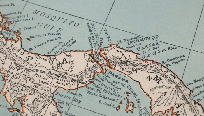
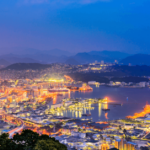
The Gulf of Panama is a large inlet of the Pacific Ocean, bordering the southern coast of Panama, a transcontinental country lying amidst Central and South America. It has a 2400 square kilometre-long coastline dotted with numerous coastal settlements, small fishing villages, ports and harbours.
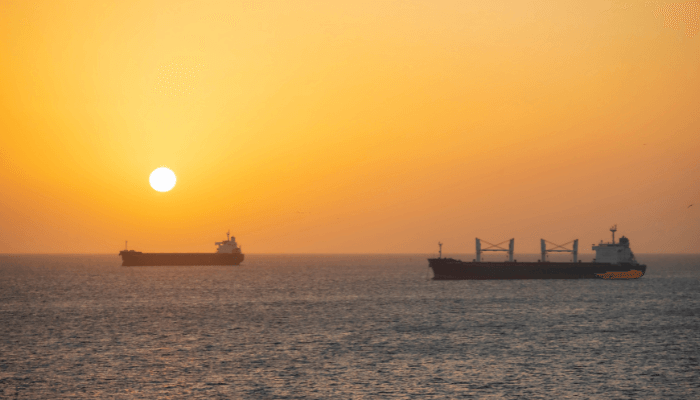
The Gulf is 250 kilometres wide and its waters reach a maximum depth of 220 metres. It is linked to the Caribbean Sea through the Isthmus of Panama. The former connects the Atlantic and the Pacific Oceans and is a crucial commercial waterway crossed by thousands of maritime vessels each year.
Mentioned below are a few interesting Gulf of Panama Facts.
1. Tectonic plate movement created the Gulf of Panama, 3 million years ago
Around twenty-five million years ago, the North and South American continents were separate and there was an exchange and intermingling of the Atlantic and the Pacific waters. However, beneath the ocean floor, the Pacific plate was pressing against the Caribbean plate, leading to the collision of the Central American peninsula with South America.
The collision created intense pressure and generated heat, giving rise to volcanoes. Some of these volatile volcanoes rose to enormous heights and emerged from the water as islands around 15 million years ago. During this period, enormous amounts of sand, soil and sediment were eroded from the North and South American coasts by powerful currents. They were deposited at the edges of the newly-formed island groups until the isthmus of Panama was formed. The shifting tectonic plates enlarged the depression and formed the Gulf of Panama about 3 million years ago.
According to Scientists, the formation of the isthmus and the Gulf of Panama is one of the most important geological events in the history of the planet. These structures changed the earth’s climate and impacted its environment and biodiversity. By limiting the water flow between the Pacific and the Atlantic oceans, the Gulf stream came into existence, suggested by Henry Fairfield Osborn, an American palaeontologist in 1910. Thus, it changed the ocean circulation pattern, altered the world’s climate and determined rainfall patterns across the globe.
2. Contains three minor bays- Panama Bay, Parita Bay and San Miguel
Panama Bay is a part of the larger Gulf of Panama and surrounds it from the northern side. A large water body, it suffers from intense eutrophication. The lack of proper wastewater treatment technologies has resulted in the pollution of Panama bay. Factories, manufacturing plants and cities along the bay dump their untreated wastewater into the Bay. This has largely impacted the fisheries, especially shellfish and crabs. The government has taken significant attempts to restore the quality of the bay’s waters.
Another important gulf is the Bay of Parita or Parita Gulf, lying off the Herrera coast in Panama. It forms the western arm of Panama Gulf and lies amidst wetlands and mudflats formed at the mouth of the River Rio Grande.
The mudflats cover 15,000 hectares of land area and stretch from Anton to the La Villa river banks in the south. A unique intertidal habitat is formed by the wetlands and mangroves near Aguadulce. The coastal areas of the Bay are segregated into three wildlife protection zones; the Cenegon del Mangle Refuge, the National Reserve of Sarigua and the Penon de Honda Wildlife Park.
Parita Bay is home to thousands of migratory bird species. Several rivers enrich the waters of the Parita Gulf such as the 150 kilometres long Hondo river which drains into the bay after flowing in a northeasterly direction. Others like Santa Maria and Grande rivers also drain into the Parita Bay which houses the American crocodile and otters.
Panama Gulf is bounded from the east by San Miguel Bay, located on the pacific coastline of the eastern Panamanian province of Darian. The largest river of Panama, the 170-kilometre-long Turia feeds the San Miguel Bay. It originates in the Darien highlands and drains into the bay, supporting tropical rainforests and the indigenous Choco people. Point Garachina is the southern tip of the bay while Punta San Lorenzo forms its northern edge.
3. Isla Del Ray is the largest island in the Panama Gulf
Pearl Island is a group of 200 small landmasses situated about 50 kilometres off the Pacific coastline of Panama. Some of the islands are inhabited by native people while others are isolated. They were discovered by the Spanish Crown in 1513 by a conquistador, Vasco Nunez de Balboa. He named them the Pearl islands due to the abundance of pearls in their lagoons.
Spain imported African slaves to harvest pearls and work in the banana plantations. The descendants of the erstwhile slaves now form a significant proportion of the island’s population. After suffering the wrath of pirates, the island was left untouched in the late 1990s and developed as a tourist destination.
Isla Del Ray is the biggest island of the group, spanning 234 square kilometres. It was named the Island of the King by European missionaries in the 18th century. The island is a popular resort town and has numerous commercial centres like San Miguel. It is also the second-largest island of Panama.
Notable islands in the archipelago consist of Bolano, Lampon, Mina, Pachea, Pedro Gonzalez, Isla San Jose, Vivenda islands and so on.
The island of Contadora has a rich cultural heritage, forts and Spanish buildings. Spanish Conquistadors stored war booty on the island before returning to their homeland. Presently, the island is famous for its beautiful resorts and heritage hotels. Beach-side bungalows and hotels on the island are owned by the rich business class of Panama.
Galera island is filled with coconut palm trees and expansive white sandy beaches. It witnesses powerful ocean currents and the coral reefs surround the island from all sides. Galera is also known for scuba-diving, boating and underwater caves.
Pre-Columbian artefacts have been found at Contadora and Isla del Ray islands, indicating the presence of ancient cultures. An environmental organisation, the Chamber for Sustainable tourism strives to protect the diverse flora and fauna of these islands.
4. Hot and humid weather with plenty of rainfall
The Pacific and Atlantic coasts of Panama witness different climatic conditions. The Caribbean shores receive heavy rainfall while the gulf of Panama coast receives 1140 to 2300 mm of rainfall annually. However, there is a regional variation in rainfall distribution patterns. For instance, the Chiriqui region has hot and dry summers, March being the hottest month.
The Caribbean side is covered with tropical rainforests while the Pacific coast has tropical grasslands or savannas. Rainfall increases on both sides of the Panama Canal as one moves close to the Colombian border. The Gulf of Panama has shallow waters and mild, pleasant winters. The temperature does not drop beyond 26 degrees Celsius.
Panamanian mountains give rise to three different weather zones; the low-lying region has hot and dry weather. Lying below 700 metres, it makes up the largest portion of the nation’s territory. The temperate zone is found between 2400 to 4800 feet while the cold zone lies above 5000 feet. Each climatic zone has different kinds of soil and natural resources. The cacao plant used for making chocolate is cultivated in low-lying areas while coffee and tea are grown on terraces.
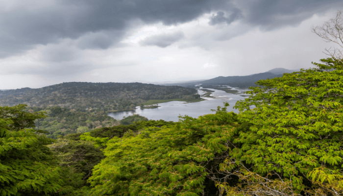
5. The Gulf of Panama Mangroves form a diverse ecosystem
Mangroves on the pacific coastline facing the Panama Gulf cover 900 square miles, stretching from Parita bay to San Miguel Bay. A unique ecoregion, they are susceptible to seasonal floods or harsh storms, a consequence of El Nino oscillations.
They are dense on the eastern side which receives heavy rainfall and contains abundant freshwater. The outer mangroves are fed by streams and estuaries. The mangroves are dotted with a few wetlands that support wildlife during hot and dry seasons.
Panama gulf mangroves serve as important breeding grounds for several bird and animal species. The wetlands fall under the protection of the Ramsar Convention. They have been categorised as endangered zones by the World Wildlife Fund for Nature.
The city of Panama has a few mangroves located on Punta Mala Bay, close to the Panama Canal. According to research, the mangroves in Panama dwindled due to construction works, agricultural activities, excessive grazing and shrimp cultivation. Around 900 hectares of mangroves were lost in the 1980s. Today, they are an intrinsic part of the local communities who depend on the mangroves for timber, fish, fuel wood and resin.
6. Populated by 20 kinds of birds and several mammalian species
Brown pelicans can be easily spotted on the bay while cattle egrets and sooty terns are also common. Herons, frigatebirds, glossy ibis etc also breed near the coastal areas. Mammals like giant sea turtles, racoons, tamandua, porcupines, anteaters and reptiles including iguanas, snakes, lizards etc are also found. Ponds containing shrimp and agricultural lands are perfect for Amazon kingfishers, nighthawks, spoonbills, coatings and other water birds.
A considerable portion of Panama is occupied by national parks and wildlife reserves, known for their lush green landscape. The wildlife reserve of Darien was formed in 1981 and is part of UNESCO’S World Heritage list. One of the oldest national parks is La Amistad, which opened in 1988.
7. Gulf of Panama supports a diverse economy
Panama Gulf plays a crucial role in the country’s economy by boosting tourism and supporting the services sector. The construction of the Panama canal has also added to economic prosperity.
Agriculture and fishing employ a large rural population but contribute meagrely to the GDP. Sugarcane, maize, tangerines, coffee, cocoa, bananas and rice are exported. Many communities raise cattle and pigs for sustenance. However commercial cattle farms are located in the southern parts of Panama.
The Gulf of Panama has tropical forests which provide valuable raw material for industrial purposes. Sawmills are dependent on Mahogany and cedar wood while logs, timber and other forest products are shipped to neighbouring countries. However, deforestation is a major concern as forests are cleared and converted into pasture lands.
Shrimp, crabs, shellfish and lobsters are exported. Herring and anchovies are caught in the shallow waters of the Bay. Panama has numerous food processing units and oil refineries. The manufacturing sector produces all sorts of goods ranging from clothes to paper, chemicals, alcohol and much more.
8. Gulf of Panama provides exciting adventures to travel enthusiasts
The Panama Canal is just one of the many fascinating places to see in the country. Also called the Crossroads of the Americas, Panama is a top tourist destination in the world.
Playa Las Lajas is a white sandy beach on the Pacific coast, facing the Panama Gulf. It is ideal for swimming and surfing. Isla Taboga beach is twenty kilometres from Panama and is famous for jet skiing, boating and fishing. It was founded by the Spanish in 1510 who established the first European settlement in the region.
Amador Causeway is the perfect spot for walking and cycling. It offers a stunning view of the city and the Bridge of the Americas. One can go mountaineering or hiking at Sendero Los Quetzales. A nine-kilometre-long trail, it passes through the jungles of Parque Nacional Volcán Barú and goes all the way to the Boquete mountains.
The waters of the Panama Gulf contain more than 750 species of aquatic plants and animals. People can visit the Coiba National Marine Park to enjoy the natural beauty of Panama. Also, one can expect to see humpback whales and their babies between June and November.
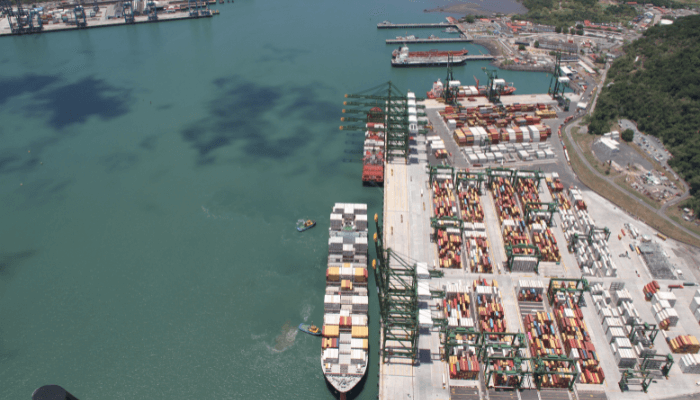
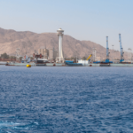
9. Panama Gulf has many important seaports
Situated on the bay of Parita, Aguadulce port faces the Pacific coast. It has a 250-metre-long pier for handling break bulk such as sugar and molasses. The deepsea harbour of Balboa has 19 berthing facilities for accommodating general cargo ships, container carriers and passenger boats. It also provides fuelling, ship repair and maintenance services. Approximately 2,000,000 TEUs and over 20 cruise ships pass through the port annually.
La Palma lies on the coast of Darien, an eastern province of Panama. It deals with timber, logs, vegetables and fruits. The port has seven wharves which handle 50,000 tonnes of cargo each year. It has more than 18 reefer connections and 2000 m2 of open storage areas.
Vacamonte is a fishing harbour facing the Panama Gulf. It can receive fishing vessels with a maximum LOA of 120 metres, weighing not more than 3000 tonnes. Main catches include shrimp and tuna. Two seafood processing plants lie in the port vicinity.
Charco Azul is an oil terminal located on the Pacific coastline. It has two loading and unloading piers and three storage tanks for keeping crude oil and petroleum. The oil jetties can easily accommodate Panamax-size oil tankers.
You might also like to read:
- 11 Important Facts About The Sea Of Japan
- 9 Interesting Facts About the Weddell Sea
- 10 Amazing Facts about Baltic Sea
- 10 Facts About The Laccadive Sea
- 10 Interesting Facts About The Tasman Sea
Disclaimer :
The information contained in this website is for general information purposes only. While we endeavour to keep the information up to date and correct, we make no representations or warranties of any kind, express or implied, about the completeness, accuracy, reliability, suitability or availability with respect to the website or the information, products, services, or related graphics contained on the website for any purpose. Any reliance you place on such information is therefore strictly at your own risk.
In no event will we be liable for any loss or damage including without limitation, indirect or consequential loss or damage, or any loss or damage whatsoever arising from loss of data or profits arising out of, or in connection with, the use of this website.
Do you have info to share with us ? Suggest a correction
Disclaimer :
The information contained in this website is for general information purposes only. While we endeavour to keep the information up to date and correct, we make no representations or warranties of any kind, express or implied, about the completeness, accuracy, reliability, suitability or availability with respect to the website or the information, products, services, or related graphics contained on the website for any purpose. Any reliance you place on such information is therefore strictly at your own risk.
In no event will we be liable for any loss or damage including without limitation, indirect or consequential loss or damage, or any loss or damage whatsoever arising from loss of data or profits arising out of, or in connection with, the use of this website.

About Author
Zahra is an alumna of Miranda House, University of Delhi. She is an avid writer, possessing immaculate research and editing skills. Author of several academic papers, she has also worked as a freelance writer, producing many technical, creative and marketing pieces. A true aesthete at heart, she loves books a little more than anything else.
Latest Maritime Knowledge Articles You Would Like:


Subscribe To Our Newsletters
By subscribing, you agree to our Privacy Policy and may receive occasional deal communications; you can unsubscribe anytime.