

5 Effective Radar Techniques for Ship Navigators – Part 1
Note: This is the first article in the ship navigation series by the very experienced Captain Ashish Joshi.
RADAR (radio detection and ranging) equipment has for a long time been one of the best tools for enhancing the safety of ship navigation at sea. Gone are the days when the master would be the one switching the equipment “on” and “off”, at his/her discretion, and when old timers would sneer at a young officer on seeing him use the RADAR. If the radar was fitted with a capable ARPA it was a real luxury on the navigation bridge of the vessel.
Thanks to the manufacturers, IMO performance specifications and regular feedback from the maritime fraternity the equipment itself has become user-friendly. Technology has improved immensely and the end product is nowhere near to the original equipment that required manual plotting techniques sheets and chinagraph pencils that tested the patience of the navigators and made it difficult to track multiple targets simultaneously.
Almost all radars today are fitted with an ARPA (automatic radar plotting aid), therefore when not being used for coastal navigation, the radar is mainly used for collision avoidance.
Regulations for proper use for collision avoidance are mentioned in COLREGS rules 6,7,8 and 19; where rule 5 says that all available means must be used for keeping a proper lookout and that includes the use of radar. Rule 9 requirement to keep as near as possible to the starboard side of a narrow channel or fairway would also necessitate the use of radar.
Related Reading: 15 Things To Consider While Using Radar On Ship
Few items are now being discussed regarding the use of radar and this list is by no means exhaustive:
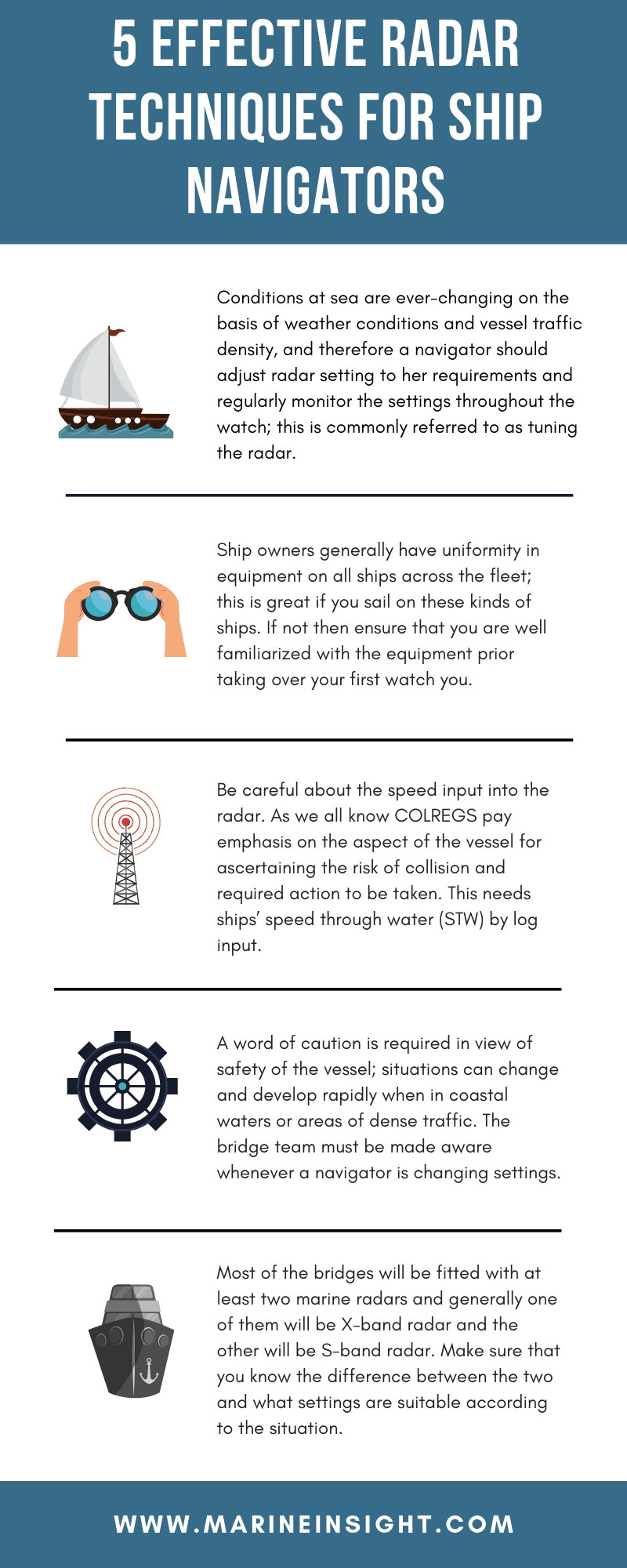
1. Conditions at sea are ever-changing on the basis of weather conditions and vessel traffic density, and therefore a navigator should adjust radar setting to her requirements and regularly monitor the settings throughout the watch; this is commonly referred to as tuning the radar. For example, if it was raining during Chief Mate’s watch and the sky is clear during your watch, you definitely don’t need to apply rain clutter. This is applicable for other radar controls too. Not many navigators are aware of this, but improper use of clutter controls can mask targets or hamper their tracking. Similarly, range scale would depend on traffic condition and type of traffic being encountered as well as on your own ship’s speed.
Some radars have settings preset depending on the type of the situation and expected use, make sure that you are aware of such settings. It is fine if such presets have names, however, be careful in case they have numbers, e.g. Picture 1 on your previous ship’s radar may not be same as Picture 1 on your present ship’s radar.
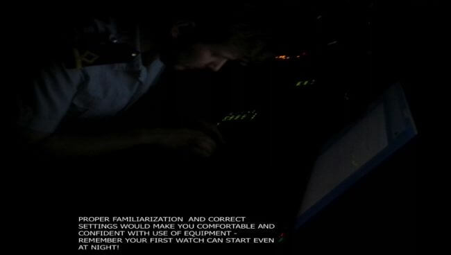
2. Ship owners generally have uniformity in equipment on all ships across the fleet; this is great if you sail on these kinds of ships. If not then ensure that you are well familiarized with the equipment prior taking over your first watch you. Get all the information so that you are confident during your watch. Information can be obtained from your predecessor, other navigators or the user manual.
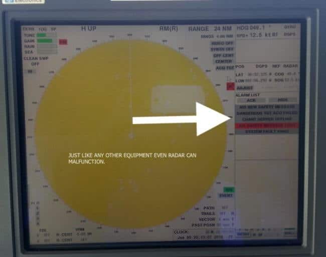
Like all marine navigation electronics, radar can also fail and you will need to know how to reset the equipment when needed. Nowadays we don’t have radio officer, or sometimes not even electrical officer at sea. You must know where radar spare parts are stored and be ready do some minor maintenance like changing the magnetron.
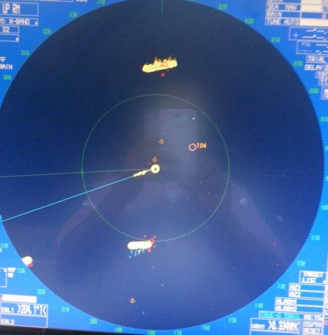
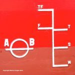
3. Another setting to be careful about is the speed input into the radar. As we all know COLREGS pay emphasis on the aspect of the vessel for ascertaining the risk of collision and required action to be taken. This needs ships’ speed through water (STW) by log input. Here is a look at the correct setting for collision avoidance using STW.
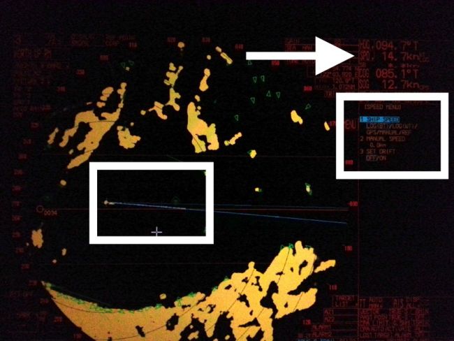
This would be great if the only job on the bridge was collision avoidance. But there is also a need for situational awareness during coastal navigation and for ascertaining set and drift speed through the ground is needed via GPS input. Improper monitoring of a vessel at this critical time has been the root cause of several collisions and allisions even by experienced ship handlers.
Here is a look at setting on the radar with speed over ground setting (SOG) by GPS input.
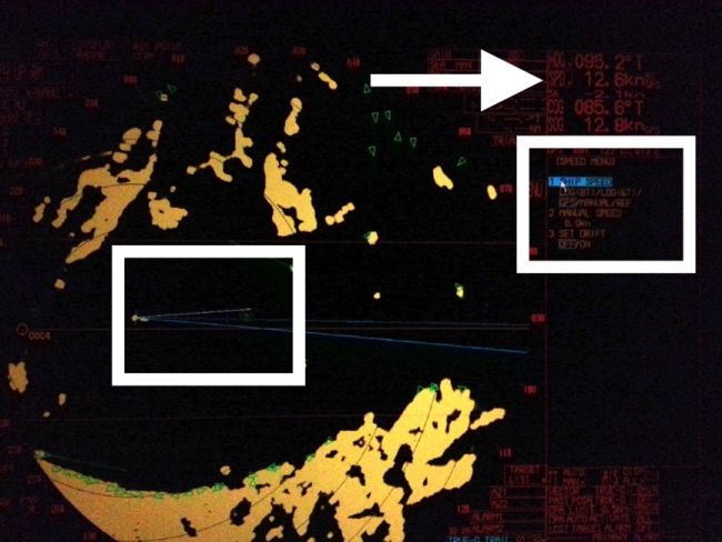
Both the pictures above were taken about 15 seconds apart and a navigator should be able to differentiate between the two radar pictures and also appreciate the need for using both the settings as situation demands.
You can also see that log speed will give the illusion that the vessel will pass to the south of VAIS (Virtual Automatic Identification System), whereas GPS speed gives actual information as evident from the vector that vessel will pass North of VAIS.
Related Reading: Important Points Officer Of Watch Must Consider While Using Ship Radar
4. A word of caution is required here in view of safety of the vessel; situations can change and develop rapidly when in coastal waters or areas of dense traffic, bridge team must be made aware whenever a navigator is changing settings. Also if you are a junior navigator in the team, revert the settings back to original immediately after making your observation.
This information regarding change of settings must also be borne in mind when a radar is being used by a pilot, do not change the settings as they may not be completely familiar with all aspects of your equipment and can get confused or disoriented when seeing a different picture than what is expected or they are used to.
5. Most of the bridges will be fitted with at least two marine radars and generally one of them will be X-band radar and the other will be S-band radar. Make sure that you know the difference between the two and what settings are suitable according to the situation. It is not wise to be navigating with two radars and using same range scale on both.
Many times it so happens that navigators are comfortable conning a vessel from a single location and this leads to over-dependence on one radar even when the other radar is much more suitable for the situation at hand.
Generally, due to operating frequency X band radar provides a clearer viewing screen and is used for target detection and collision avoidance. Whereas S-band radar gives better picture because it’s radio waves can penetrate through fog particles and rain.
- Proper Use Of ECDIS Safety Setting On Ships
- Important Points For Dealing With Navigational Warnings On Ships
- NAVTEX On Ships
- Pros and Cons Of ECDIS
Disclaimer: The authors’ views expressed in this article do not necessarily reflect the views of Marine Insight. Data and charts, if used, in the article have been sourced from available information and have not been authenticated by any statutory authority. The author and Marine Insight do not claim it to be accurate nor accept any responsibility for the same. The views constitute only the opinions and do not constitute any guidelines or recommendation on any course of action to be followed by the reader.
The article or images cannot be reproduced, copied, shared or used in any form without the permission of the author and Marine Insight.
Do you have info to share with us ? Suggest a correction

About Author
Capt. Ashish Joshi is presently a sailing master on container ships with a passion for teaching. At one time in his career, he used to hold classes in his ship cabin for ratings who wanted to work towards the certificate of competency! During leave, he spends time with family and on the golf course.
Latest Marine Navigation Articles You Would Like:

Subscribe To Our Newsletters
By subscribing, you agree to our Privacy Policy and may receive occasional deal communications; you can unsubscribe anytime.
I like how you talk about the challenges when using radar onboard a ship, especially when you’re out on the surface battling through a storm that’s passing through as radar and sonar can give potentially different readings when it comes to checking for location. It’s important to know that radar can potentially fail when the ship’s navigation systems get hit by a wayward thunderbolt (therefore leaving it blind) so it’s important to always have a secondary back-up system when it comes to navigating in extreme weather conditions. While I have no experience with using radar on a ship, I at least understand that navigating through rough waters on a ship can definitely be a scary thing to live through and that radar is there to help the people aboard the ship get around the area.
Which radar is best for navigation during rain?