

Real Life Incident: Paltry PPU Position Predictor
In darkness and with visibility further reduced to about 150m in fog, a container vessel was being brought to a tidal river berth under pilotage.
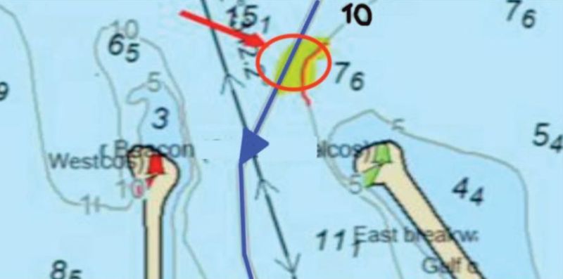
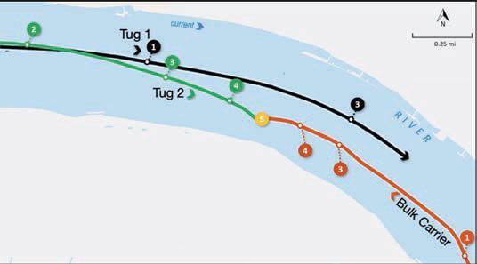
To monitor the vessel’s progress, the pilot had set up his portable pilotage unit (PPU). He had connected the rate-of-turn generator to the vessel’s pilot plug and had set a variable range marker on the radar with a radius of 0.5 nm. The PPU had a predictor that continually self-updated to display the vessel’s next six predicted positions at intervals of 30 seconds.
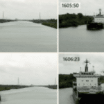
The pilot and the Master had exchanged their respective information; the passage plan, local traffic and berthing procedure (pilot) and the vessel’s condition and manoeuvring data (Master). The pilot increased the vessel’s speed in order to overcome cross-currents at the mouth of the river and then commenced a starboard turn to enter the river as normal. Soon, the vessel’s speed was about 16 knots. At this point, the Master was using the ECDIS located at the starboard conning position to monitor the vessel’s progress, while the OOW was using a paper chart.
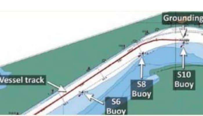
At 2150, the pilot ordered half ahead. About two minutes later the pilot ordered 15 degrees of starboard helm to initiate the turn through the next bend in the river. He then used the predictor to assess the vessel’s rate of turn. Soon he ordered the rudder angle to be reduced to 10 degrees to starboard, then to 5 degrees and finally to midships.
At 2153:20 the vessel’s speed was near 14 knots and the rate of turn was about 25 degrees/minute to starboard. About a minute later, with the speed now 13 knots, the pilot cross-checked information from the PPU predictor with the radar. The radar information showed the vessel was not proceeding as indicated on the PPU so he ordered counter rudder to port and full ahead on the engine to stop the turn to starboard and correct the vessel’s position in the channel.
This action was insufficient and the vessel grounded at 2156, within the navigable channel but in an area where silting had been reported and that the pilot knew was present. With the rising tide the team were able to re-float and dock the vessel about two hours later.
The official investigation found, among other things, that;
- The pilot’s PPU was obtaining information from the vessel’s AIS, which was subject to GPS ‘smoothing’. As a result, the predicted vessel positions displayed on the PPU were not accurately reflecting the vessel’s future positions, but the pilot was unaware of this. Also,
- The pilot did not inform the bridge team about the extent of silting within the navigable channel nor had the bridge team taken steps to obtain this information. As such, the bridge team was unable to identify or to assist the pilot in resolving the developing unsafe situation
Lessons Learned
- Had the pilot used an independent DGPS antenna for his PPU the predicted positions would probably have been more accurate than those represented by the vessel’s AIS pilot plug.
- Communication and planning is everything! The silting in the channel was not communicated to the bridge team by the pilot – but neither did the vessel’s team take the time to research this fact which was readily available via on-line sources.
- Speed changes everything! In this case the vessel was proceeding at near 13 knots (6.68m/sec) in a narrow channel in near zero visibility. Proceeding at nine knots (4.63m/sec) would have given them extra time, about one minute, to reevaluate the circumstances and manoeuvre. This would likely have prevented the grounding
Source: The Nautical Institute
Do you have info to share with us ? Suggest a correction
About Author
Marine Insight News Network is a premier source for up-to-date, comprehensive, and insightful coverage of the maritime industry. Dedicated to offering the latest news, trends, and analyses in shipping, marine technology, regulations, and global maritime affairs, Marine Insight News Network prides itself on delivering accurate, engaging, and relevant information.

- Real Life Incidents: Near Miss In Open Water And Good Visibility

- Real Life Incident: Poor Situational Awareness Leads to Collision
- Real Life Incident: Monkey’s Fist Knocks on Office Window
- Real Life Incident: Paint Storage Slip-Up On Ship
- Real Life Incident: Checklist Mentality Is A Burning Problem
- Real Life Incident: Vessel Speed Exacerbates Bank Suction


Latest Case studies Articles You Would Like:


Subscribe To Our Newsletters
By subscribing, you agree to our Privacy Policy and may receive occasional deal communications; you can unsubscribe anytime.