

UK Ports Get First Fully-Electric Remotely Operated Survey Vessel
In a first for UK ports, the Port of London Authority (PLA) and University College of London (UCL) have launched a fully electric, remotely operated survey vessel.
It will support a MSc Hydrographic Surveying course they have run in partnership since 1999.
The state-of-the-art platform, manufactured by MARITIME ROBOTICS, was acquired by the partners, following a successful bid and award of an £263,000 grant from the Engineering & Physical Sciences Research Council (EPSRC).
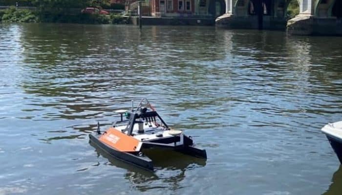
The vessel features the most advanced sonar and scanning system from technology manufacturer, NORBIT, called a WINGHEAD. This facilitates unparalleled collection of data to create detailed maps of the riverbed, and structures, such as bridges, jetties and shipwrecks that need to be surveyed and inspected to ensure accurate information for safety of navigation or maintenance.
The platform will facilitate PLA and UCL research in coastal morphology, carbon reduction, habitat mapping and other areas of education and development in the sphere of maritime safety, autonomy, and robotics.
Due to its small size and manoeuvrability, the remote platform can be deployed in situations where traditional survey vessels would be impractical or unsafe, such as shallow waters, or close inshore or around and under marine structures. Its battery- powered electric thrusters provide a much more environmentally-friendly solution than traditional marine diesel or petrol engines.
The tidal Thames is home to the UK’s port and busiest inland waterway; accurate and regularly updated riverbed data is essential to safe navigation. The PLA’s port hydrographer, John Dillon-Leetch, said:
“We’re delighted to lead the way in launching this remote surveying vessel with UCL.
“Not only does it feature the latest in innovation, thanks to NORBIT’s multibeam technology, but it also enables our hydrographers to survey in previously inaccessible areas, safely and sustainably. This aligns with two of our goals in our Thames Vision 2050 strategy, launched last year.”
The remote surveying vessel has been trialled in London’s Royal Docks and at the PLA’s Richmond Lock and Weir, by UCL’s latest cohort of international MSC students supported by the PLA Hydrographic Service Team.
Since 1999, the PLA’s Hydrography team have worked in partnership with UCL Civil, Environmental and Geomatics Engineering (CEGE) to deliver the International Hydrographic Organisation (IHO) accredited Category A MSc in Geospatial Science, Hydrographic Surveying. The only CAT A accredited course in the UK, supporting the education of future hydrographic surveyors from around the world.
UCL CEGE’s lecturer in marine geospatial science, Dr Cassandra Nanlal, explains:
“Our partnership with the PLA enables us to offer an unrivalled field course experience with a world-leading hydrography team, including use of cutting-edge equipment, such as this remote surveying vessel.
“Our international students will be able to take their experience and knowledge to all parts of the world, to help elevate the standards within the industry. This platform will facilitate interdisciplinary research at UCL with collaborations between CEGE, UCL Mechanical Engineering and UCL Geography, in alignment with the UCL Research Strategy.”
John Fraser from NORBIT commented: “We are proud to support PLA and UCL with this project which demonstrates the importance of both technical innovation and practical application.”
The emergence and growing importance of remote and autonomous surveying vessels signify a paradigm shift in the hydrographic surveying industry.
By providing a safer, more efficient, versatile, and sustainable solution for underwater data collection, these vessels will transform the way the surveyors of the future map and analyse data of the world’s riverbeds and ocean floors as well as paving the way for a more technologically driven and sustainable future in maritime operations.
—————-
The Port of London Authority (PLA)
Covering 95 miles of the tidal River Thames, the Port of London Authority (PLA) works to keep commercial and leisure users safe, protects and enhances the environment and promotes the use of the river for trade and travel. As a trust port, the PLA has no shareholders and operates for the benefit of customers and stakeholders, now and in the future.
UCL Department of Civil Environmental and Geomatics Engineering (CEGE)
UCL Civil, Environmental & Geomatic Engineering (CEGE) is dedicated to creating engineering solutions for a sustainable future, fuelled by creativity, collaboration, and communication that drive social impact. Our department takes pride in its substantial EPSRC research portfolio and extensive academic portfolio in civil engineering, which offers the world leading IBSC CAT A accredited Hydrographic Surveying MSc — the sole programme of its kind in the United Kingdom.
Press Release
Disclaimer :
The information contained in this website is for general information purposes only. While we endeavour to keep the information up to date and correct, we make no representations or warranties of any kind, express or implied, about the completeness, accuracy, reliability, suitability or availability with respect to the website or the information, products, services, or related graphics contained on the website for any purpose. Any reliance you place on such information is therefore strictly at your own risk.
In no event will we be liable for any loss or damage including without limitation, indirect or consequential loss or damage, or any loss or damage whatsoever arising from loss of data or profits arising out of, or in connection with, the use of this website.
Do you have info to share with us ? Suggest a correction
About Author
Marine Insight News Network is a premier source for up-to-date, comprehensive, and insightful coverage of the maritime industry. Dedicated to offering the latest news, trends, and analyses in shipping, marine technology, regulations, and global maritime affairs, Marine Insight News Network prides itself on delivering accurate, engaging, and relevant information.

Latest Shipping News Articles You Would Like:

Subscribe To Our Newsletters
By subscribing, you agree to our Privacy Policy and may receive occasional deal communications; you can unsubscribe anytime.