

8 Interesting Davis Strait Facts – The Broadest Strait in the World
Straits are usually defined as a narrow passage or a waterway that lies between two land masses and connects two oceans or large bodies of water. They are formed by natural geological phenomena such as tectonic shifts.
Sediment deposition might occur on both ends of a strait, leading to the formation of deltas and underwater ridges. They also serve as a channel for the passage of ocean currents thereby regulating the region’s climate and weather conditions. Some straits can even be used to generate tidal power by employing tidal stream turbines.
They are also strategically important and play a crucial role in global maritime trade. Straits are utilised by the commercial shipping industry for transporting cargo across continents. Thus, throughout history, wars and battles have been fought to control major straits and trade routes passing through them.
Most of us are aware of the deepest strait in the world which is the Lombok strait that connects the Java Sea to the Indian Ocean or the Malacca Strait that is the biggest strait situated between the Malay peninsula and the Indonesian island of Sumatra, however, we are not aware of another significant waterway that is the Davis Strait.
In this article, let us explore some interesting facts and features of the Davis Strait.
1. Davis Strait is the broadest Strait in the world
Also known as the northern arm of the Atlantic Ocean, the Davis Strait is situated north of the Labrador Sea amidst southwestern Greenland and southeastern Baffin Island in Nunavut, Canada.
It separates the depths of northern Baffin Bay from the southern Labrador sea and forms an important part of the Northwest passage route going through the Canadian Arctic Archipelago and connecting the Atlantic and the Pacific Oceans.
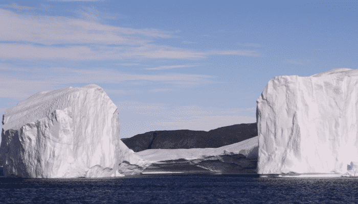
Baffin Bay is situated between Baffin Island and Greenland’s west coast. Defined as a marginal sea of the Arctic ocean, it is also considered a small sea of the North Atlantic. It is not navigable during the winter months due to the thick ice cover, floating icebergs and heavy fog.
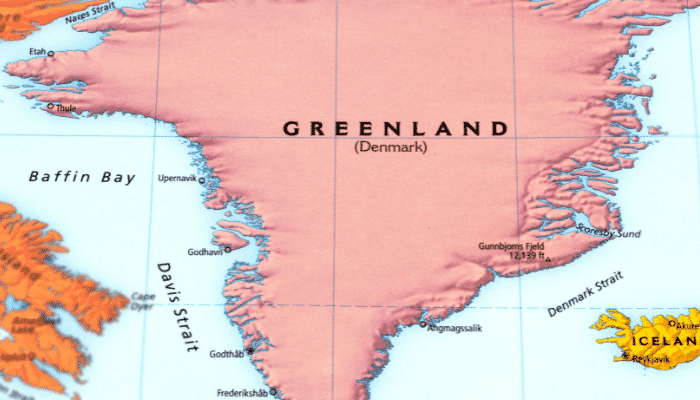
The Davis Strait stretches approximately 650 kilometres or 400 nautical miles from the north to the south and is about 400 to 200 miles wide. It has a water depth ranging from 1000 to 2000 metres and is comparatively shallower than the southern Labrador sea.
The Davis Strait is home to complex geological formations such as underwater basins and ridges that were created due to the strike-slip faulting along the Ungava fault Zone around 45 to 62 million years ago. It triggered plate tectonic movements in the Labrador Sea and the Baffin Bay leading to the formation of the Strait.
2. Named after an English Explorer called John Davis
The Davis Strait was named after an English explorer who found this waterway on one of the three voyages undertaken between 1585 and 1587. He sought to find a northern trade route to the Pacific Ocean and his explorations were funded by the British crown. Though the northwest passage was uncovered only in 1906, his voyages provided valuable insights that informed later expeditions.
His first voyage was unsuccessful as he sailed around the eastern coast of Greenland, Cape Farewell and Cumberland Sound and then turned back from Baffin Island. On his second journey, he passed the strait named after him and reached the Bay of Baffin. Upon reaching Diko island, he encountered the Eskimos of Greenland. Apart from the Davis Strait, many other Arctic points such as the Cape of Walsingham and Cumberland Sound were named by him.
In his last voyage, he commanded the famous ship, Black dog in a tussle with the Spanish Armada in 1588. He was accompanied by Thomas Cavendish while trying to find a route through the Magellan Strait. During this voyage, he discovered the Falkland Islands and also sailed to Cadiz and Azores. He was killed by Japanese pirates in one of his later expeditions to the East Indies but made significant contributions in the field of cartography and navigation.
He also wrote a book called the Seamen’s Secret describing all the unique experiences of his journeys, and another work on the northwest route known as the World’s Hydrographical Description. However, he is famous for his invention of the backstaff or the Davis Quadrant which was widely used by sailors till the 18th century.
3. Temperature difference in the strait gives rise to Beautiful Cloud Streets
Two different ocean currents are active in the Davis Strait having contrasting temperatures leading to varying concentrations of ice on the eastern and the western sides of the Strait. From the shores of Greenland, the western Greenland current carries comparatively warmer waters towards the east while the Labrador current pushes iceberg filled water southward along the Canadian coast, the Labrador sea and subsequently the Atlantic.
As a result, one can witness ice-caps blocking much of the northern part of the Strait while beneath the streamers of clouds, we can see water opening up in the east due to warmer ocean currents.
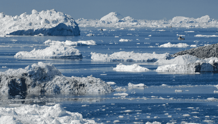
The streamers of clouds, also known as cloud streets are formed by drastic temperature variations and the circulation of a hot and cold ocean current simultaneously. In this case, they are formed due to the cold arctic air moving over regions of warmer, open waters of the Strait. The clouds are denser and aligned in the direction of low-level wind, with swirling air vortices leading to the creation of beautiful cloud patterns. The Davis Strait is also known for its high tides that range between 30 feet to 60 feet.
4. Has complex hydrography and a diverse marine ecosystem
The varied topography of the Strait gives rise to rich aquatic biodiversity. The greatest water depths in the eastern Arctic ocean are reached at 3660 m in the southern part of the Davis Strait. At the narrowest point, it comprises a 600 m deep underwater sea ridge that is a continuation of the Labrador ridge, spanning from the Baffin island coast to Greenland. The numerous sea slopes located along the Labrador sea flank of this ridge and the coast of western Greenland have a depth of 2500 m and more.
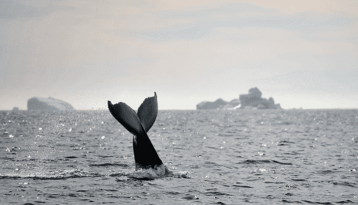
Thousands of coral colonies and many types of sponges, sea anemones and colourful fish, including Greenland’s only Lophelia Pertusa reef, are found in the deep sea slopes of the strait. One of the six rare species of corals, the Lophelia Pertusa are known to form cold-water reefs and unlike many warm-water corals, these do not require any light to grow and flourish.
The Davis Strait has an abyssal plain on either side including sea shelves stretching from the shores of Canada and Greenland, with a water depth ranging from 20 m to 100 m, cutting across deep troughs.
During the summer months, the southern Davis Strait is filled with phytoplankton blooms that spread northward into the Baffin Bay in May, as the ice cover begins to retreat. Possessing high biomass, these phytoplankton blooms feed many small fish and also crustaceans like the copepods which are ultimately consumed by larger fish, seabirds and whales.
5. The Davis Strait and the Baffin Bay possess large-scale commercial fisheries
The Davis Strait region was home to several indigenous communities for centuries. The first European to ever set foot in the coastal areas was a Norwegian Viking named Erik the Red who arrived in Greenland in 985 AD. His descendants hunted walrus and seals in the Strait for over 500 years. After the decline of the Viking settlements, the Dutch and English arrived intending to hunt bowhead whales. A whale-oil rush commenced in the early 1800s but large scale fisheries developed only after the second world war ended and the fishing fleets of the Soviets, Polish and Germans expanded significantly.
Commercial fishing began in the Davis Strait and the Baffin Bay only in the late 1900s. During that period, local fishermen communities hailing from Canada and Greenland sought grenadier and redfish. Over-exploitation led to the collapse of these fisheries in the 1970s. The Soviet Union laid the foundation of an industrial Greenland Halibut fishery in the 1980s and Atlantic fishermen focussed on catching shrimp in the Strait’s waters as cod populations declined to abysmal levels in the waters of the Canadian Atlantic.
Presently, the Greenland Halibut or turbot is the mainstay of the region’s fishing industry along with bottom-trawling operations for catching shrimp and crabs. However, these complex fisheries are shared between Canada and Greenland. Questions over equitable distribution of fishing rights, catch allocations etc have often led to disputes between the two parties. Inuit companies in the region have recently begun to address and acknowledge the inequalities in allocation.
6. Over-exploitation is leading to a decline in the region’s fish population
Another worrisome aspect that has come to light is over-fishing in the Strait’s waters which is adversely affecting the fragile marine ecosystem. Excessive fishing of Greenland halibut and shrimp has impacted the food supplies of whales residing in the Baffin Bay region. According to the stomach content analysis of the Narwhal, around half of its diet consists of Greenland Halibut.
Though a migratory species, halibut breed in the shallow waters of the Baffin Bay and the Davis Strait and are frequently caught by deep-sea trawlers when they are not even mature. Thus, it has threatened the existence of whales, shrimp and halibut as human activity has created a large ecological imbalance that can only be resolved by reverting to sustainable fishing practices.
Many environmental organisations have highlighted the urgent need for protecting the region’s fisheries. One such is the Oceans North, a charitable group focussing on community-based conservation in the Arctic and Atlantic regions of Canada and western Greenland. This organisation has suggested the creation of marine protected areas for naturally reviving the Greenland Halibut and shrimp populations, raising awareness for protecting the habitat of cold-water corals and sponges by banning commercial fishing past 72 degrees north in the Baffin Bay.
7. Around 16 port facilities are located along the Davis Strait
The Davis Strait has many ports and harbours belonging to the nations of Canada and Greenland. The Iqaluit harbour is situated amidst the Everett mountains and rises from the Koojesse inlet lying at the mouth of the Frobisher Bay on southeastern Baffin Island.
It is a multipurpose port serving the community of the Baffin island and is navigable from July to October. Cargo operations are carried out at the anchorage while dry cargo is transported to the shore through lighters and barges. The port city is the capital of Nunavut and also an important administrative, communications and transhipment hub of the eastern Arctic.
Another important port of the Davis Strait is the Aasiaat port, also known as Egedesminde, lying on the northwestern coast of Greenland. It is an important distribution centre of goods in northern Greenland. It handles general cargo, container goods, packaged food items etc and remains ice-free from May till December.
The largest port of Greenland is the Nuuk harbour lying in the southeastern part of the Old Nuuk city. The port is operational in the summer months as the entrance channel is surrounded by icebergs during winter. The inner port has a marina capable of accommodating small vessels and ferries. Larger commercial ships are berthed in the eastern port area. It also has a container terminal with 10 hectares of storage space dedicated to container stacking and processing.
Port of Sisimiut, also called Holsteinborg, is located on the western coast of Greenland. It is divided into an inner port area and an outer harbour providing accommodation for general cargo vessels, bulk carriers, small boats and also fishing vessels. An important facility, it handles around 62,000 tonnes of cargo every year.
8. Davis Strait possesses rich reserves of natural gas and crude oil
Recent surveys undertaken by the United States Geological department have revealed the presence of large oil deposits and gas pockets around the Arctic Ocean. It has also been found that seas near the coast of Greenland might hold large amounts of natural gas and crude oil. Hence, the provincial council of the island nation has offered offshore concessions in seas lying to the west of Greenland, particularly in the Davis Strait and the Baffin Bay for the extraction of these natural resources.
You might also like to read:
- 10 Facts of Marmara Sea You Might Not Know
- 10 Interesting Facts About The Tasman Sea
- 10 Azov Sea Facts You Might Not Know
- 10 Amazing Facts about Baltic Sea
- 10 Amazing Facts About The Aral Sea
Disclaimer: The authors’ views expressed in this article do not necessarily reflect the views of Marine Insight. Data and charts, if used, in the article have been sourced from available information and have not been authenticated by any statutory authority. The author and Marine Insight do not claim it to be accurate nor accept any responsibility for the same. The views constitute only the opinions and do not constitute any guidelines or recommendations on any course of action to be followed by the reader.
Do you have info to share with us ? Suggest a correction

About Author
Shilavadra Bhattacharjee is a shipbroker with a background in commercial operations after having sailed onboard as a Third Officer. His interests primarily lie in the energy sector, books and travelling.

Subscribe To Our Newsletters
By subscribing, you agree to our Privacy Policy and may receive occasional deal communications; you can unsubscribe anytime.