

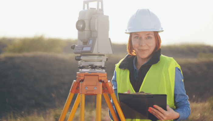
A Guide to Hydrographic Surveys
Earth’s water bodies cover over 70% of the planet. Along with building ships that travel over the surface of the oceans, it is important to learn about the seabed and sub-surface topography. This is achieved by conducting underwater studies known as Hydrographic Surveys.
In this article, we will look at hydrographic surveys, the different types of surveys, and the various equipment used.
Introduction to Surveying
Also known as underwater surveying, hydrography is the science of determining the features of an underwater area. The features to be studied include the water depth, topographic features, tide measurement etc. Simply put, being able to understand the contortions and elevations of the ocean floor has many practical uses.
An important type of hydrographic surveys is the bathymetric survey, which originates from the Greek terms bathus (deep) and metron (measurement). This is the underwater equivalent to a land survey operation known as hypsometry.
Unlike land surveys that use static or stationary equipment to conduct measurements, bathymetry involves a dynamic ship that is moving while carrying out observations. Thus, special allowances have to be made for any error that arises out of this motion. This type of surveying is covered in the next section.
The primary purpose of hydrographic surveying is in water depth estimation, which is achieved by bathymetric surveys. Some of the other most common uses of hydrographic surveying include waterway planning, dredging analysis, and wreck location.
Another application of surveying is in the construction and planning for docks, harbours, and dams. It is important to ensure that the water depth in and around ports are sufficient to allow for ships to safely enter and berth. Also, the portion of the seabed that supports floating structures must have a strong foundation. Dams also require adequate knowledge of the surrounding terrain to ensure structural strength.
Surveying allows engineers to plan land reclamation activities. By revealing data on the seabed composition and topography, sites to carry out reclamation can be selected. In addition, engineers can determine the feasibility of projects in the planning phase itself. Surveying also aids in flood control systems, by predicting possible flooding zones and suggesting measures to effectively counter this. Flooding zones can be predicted by studying how the ocean floor changes around the coastline and by correlating this structure with any historic records of flooding or tsunamis.
Another application of underwater surveying is in determining shorelines that extend around a coast. Preparing shore line charts are useful in conducting studies on the effect of water bodies on land, and for determining the actual maritime border of countries. Surveying also determines the mean sea level that plays a very important role in almost every sphere of life. From aiding the government in charting coastlines, they also affect the launch of space shuttles and rockets.
Surveying also helps in ship navigation, by providing possible paths that a vessel can take. Certain ocean routes may lie at low depths or may have rocks and coral deposits. This poses a major danger to ships and hence needs to be recorded properly. By charting safe routes that do not cross any dangerous terrain, surveying helps the shipping industry. Surveying also has agricultural uses, by determining alluvial and silt deposits near water bodies. As deltas have incredibly fertile lands, such areas can be specifically allotted for farming activities. Also, by studying river discharge, erosion and its effects on arable land can be studied.
One of the most important purposes of hydrography is in the field of dredging. Dredging is defined as the removal of weeds, mud, and rocks at the seabed. This can be for creating inland waterways to promote the shipping industry. By creating sufficient depth in rivers, small ships can be used to supplement domestic trade. Dredging may also be carried out to change drainage patterns that affect irrigation, erosion etc. Underwater surveying collects information that is often the basis for approving capital projects. Surveying also aids in the offshore industry by allowing for remote maintenance checks on oil and gas structures. Hydrographic surveys can replace manual checks, by estimating wear and tear on the structure. Similarly, when laying seabed pipelines, surveying ensures that pipe tracks are constructed correctly.
Bathymetric Surveys
In this section, we will analyze bathymetry and its primary output- bathymetric charts. Bathymetric charts produce contour lines to show relative terrain relief. These contours are also known as isobaths, indicating relief using colour gradients.
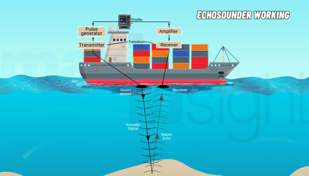
The earliest technique to measuring ocean depth involved lowering a weighted cable until it made contact with the seabed. However, this is time-intensive in addition to being inaccurate. Thus, the present technique is to use depth sounding which uses sound waves. Bathymetric maps are produced by analyzing data from echo sounders located on research vessels. A beam of sound is pinged towards the seabed through a transducer, while a receiver is used to analyze the reflected beam. By measuring the time taken to bounce back, and accounting for appropriate corrections, the depth of the bed at that particular point can be measured. Modern echo sounders use multiple beams closely packed within an angle of 90⁰ to 170⁰. This results in high-resolution charts and also reduces the time taken to map a certain area.
Satellites can also be used to generate bathymetric plots, although it is a complex process. The method involves analyzing sea-level fluctuations caused by undersea terrains such as mountains and ridges. The sea level is higher over terrain changes such as mountains and ridges, as compared to trenches and plains.
Types of Surveys
There are five main types of hydrographic surveys, although other subsets of these surveys are also used.
General hydrographic surveys refer to studies of the water depth, mean sea level, determination of coastlines, and bathymetric plots. They are the most common type of survey. These surveys have applications in science and geological studies.
Harbor and port surveys are conducted to determine the ideal locations to build these structures. Undertaken by national governments, they analyze the best possible places that do not have draft restrictions on vessels. For instance, some lagoons may be surrounded by corals that prevent ships from approaching the mainland. These factors must be taken care of prior to constructing a port. Additionally, the underwater supports on which the pier floats must also be solidly supported. Loose mud or silt may tend to rock this foundation over time, and dredging may be required.
Passage surveys are used to determine the condition of inland waterways, with the aim of turning them into passages for ships to ply through. Undertaken to increase productivity and trade, this survey looks at analyzing mean draft, the width of the passage, and the restrictions that must be imposed on the size of the vessels. Additionally, passage surveys study the feasibility of creating straits, similar to the Panama or Suez Canal.
Coastal surveys are undertaken to study the coastline of a country and document the flora and fauna living near it. This survey is usually undertaken within the maritime boundaries of the nation extending up to 200 nautical miles beyond the coast. They also aid in studying possible land reclamation project.
Wreckage surveys are conducted to study the position of wreckage. It can be conducted as part of an investigative effort to determine the probable cause for the vessel to sink, or maybe a part of the salvage process. Vessels sink due to flooding that occurs through the hull. It is viable to have experienced hydrographers analyze the site of the wreckage. They can provide insight into the structural damage and possible reasons for flooding. During salvage operations, it is important to ensure that no damage occurs to both the vessel and the surrounding areas. Thus, by running tests on the regions on which the wreck sits, a viable method of salvaging can be chosen.

Equipment and Technology Used
Echosounders are a class of sonars that have been discussed in the section on bathymetric surveys. By using sound beams and measuring the time lag between transmitting and receiving a signal, the depth of any waterbody can be determined. A hydro-acoustic sounder can also be used to monitor marine fauna.
Echosounders can be a single or multibeam depending on the purpose. Single beam surveys are carried out by passing beams along parallel routes and then using approximations to map depths at adjacent points. This method is not very accurate when the seabed is covered with poor reflecting material such as mud. Multibeam sounders can use anywhere over 100 beams to conduct simultaneous mapping. By using seismic reflections, the seabed layer thickness can also be analyzed.

The Side Scan Sonar is used to image large areas of the seabed at one go. It is used mainly in navigation and the detection of dangerous underwater terrain. Another device is the Acoustic Doppler Current Profile (ADCP) which acts as a sonar transducer. This machine uses the doppler effect of sound that results in wave shifts. Sound beams are transmitted through the water at different angles such that there is some phase in the reflected beams. This method is commonly used to study discharge effects on canals and rivers. Most ADCPs are used for collecting historic data over time and are built to stay underwater for protracted periods using specialized batteries.
Another commonly used device is the LiDAR (Light Detection and Ranging). The LiDAR uses light pulses to analyze the bottom of a seabed. Using lasers, a 3D image of the ocean’s topography can be rendered. It is commonly used for dredging measurements and to correctly position underwater pipelines.
A Global Positioning System (GPS) is used to determine the accurate position of the sounding boat on which the equipment is loaded. This ensures that the vessel follows a path known as a sounding line. Modern advances in GPS technology have allowed for the sounding vessel to be purely automated.
Other equipments used include buoys. Buoys are used as markers to indicate the line along which sounding is to be carried out. This line must be maintained perpendicular to the shoreline at every point and is achieved using laser-guided signals. By keeping signals along a straight line, the position of the buoy can be fixed. It is then weighted at the bottom using guywires. Lights are usually used to ensure that it is visible even at night. These days, buoys have been replaced with GPS technology.
The vessels used to conduct echo sounding include small inflatable boats, Autonomous Underwater Vehicles (AUVs), and Unmanned Underwater Vehicles (UUVs). The various scanning equipment can be attached either at the stern or at the fore of the vessel. Attaching at the stern is safer since it prevents the equipment from being damaged in case of a collision. In such cases, the scanners may be floated on dredging hoppers, and then towed by the sounding vessel. On the other hand, attaching the equipment at the fore is preferable, as it allows the crew to preempt surrounding topography. AUVs and UUVs can produce high-resolution hydrographic charts and maps as they operate underwater.
Hydrographic Surveying Methods
Hydrographic surveys can be conducted using numerous methods depending on the type of resulting data. We will look at three methods of conducting underwater surveys- line and pole surveying, wire drag surveying, and modern surveying. Prior to any survey being carried out, a basic reconnaissance of the surrounding region is required. By doing so, the surveyors know the type of terrain to expect and can calibrate the equipment accordingly.
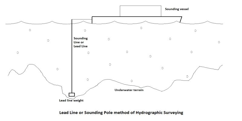
Line and pole surveying was one of the oldest systems of hydrography used. This method involved submerging a graduated lead line or a sounding pole into the water. Based on the depth at which the line or pole met the bottom, the readings were marked.
By travelling along parallel paths and taking continuous readings, a rough estimate of the underwater topography could be obtained. As it was a labour and time-intensive process, it became outdated with advances in echo sounding.
Echosounders became popular in the 1930s and allowed a single individual to record depths at a fast pace. The main issue with this method was that approximations were made for the region in between the parallel routes taken by the sounding vessel. This problem was solved using multi-beam sounders that captured large swathes of the surface in one pass.
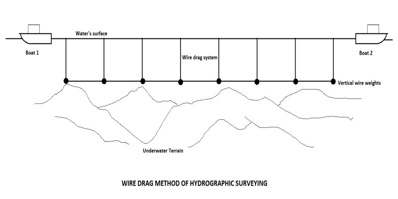
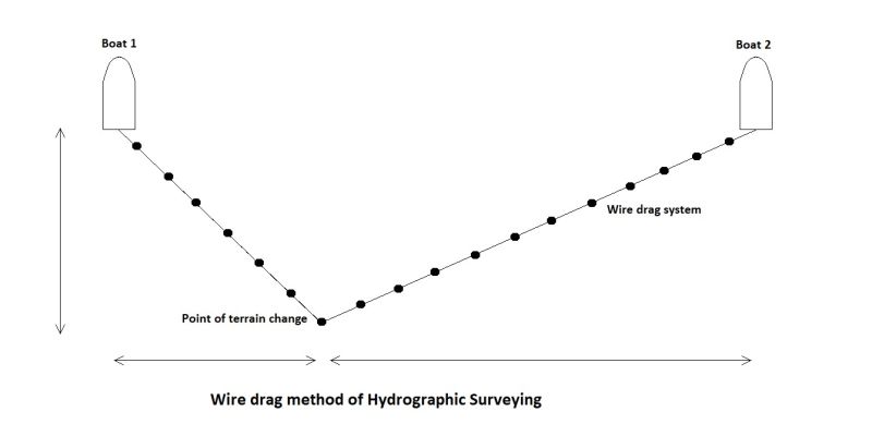
Wire drag surveying is another old method of hydrographic mapping. Developed by Nicholas Heck between 1906 and 1916, this method relies on a system of boats and wires. In this method, a wire was attached between the sterns of two boats.
The horizontal wire further had vertical weighted wires that were kept submerged. Once the area to be surveyed had been identified, buoys would mark the tracks for each boat to follow. As they moved along their routes, the wires would be dragged along.
In case any rocky obstruction rose out of the seabed, the wire at that point would become entangled. As the boats moved away, that point would become apparent, by noting a sharp change in the wire’s direction. Once analyzed, the location could be marked on special charts. With the advent of the side scan devices and multi-beam sounders, wire drag surveying gradually become redundant by the 1990s.
Modern surveys use advanced technology such as LiDAR to map hydrographic surveys. Using small crafts, the equipment can be floated out to the required areas for mapping. Other commonly used equipment includes side-scan devices, single beam, and multi-beam sounders.
Occasionally, multiple devices are used simultaneously to ensure that the collected data is accurate. In case of any discrepancy between the multiple readings, that particular area can be remapped. On completion of sounding, the data collected from the various equipment needs to process.
Since several machines may be used for one area, the data points need to be correlated for the hydrographic survey. This data is presented in the form of navigational charts, Digital Terrain Models (DTMs), volume charts, and isobath plots. Errors pertaining to pitching, heaving, and yawing must also be corrected using suitable methods. The data is generally plotted in Computer-Aided Design (CAD) software which can output 3D models.
Organizations Dealing in Underwater Surveys
The primary organizations dealing in underwater surveys are national and international bodies attached to the various governments. For instance, the National Institute of Ocean Technology (NIOT) in India, the Instituto Hidrografico de la Marina in Spain, and the National Oceanic and Atmospheric Administration (NOAA) in the United States deal with domestic hydrographic surveys.
In the international sphere, the International Maritime Organization (IMO) oversees global underwater surveys. The International Hydrographic Organization (IHO), comprising 93 member countries (as of 2019), is an intergovernmental treaty regarding international efforts in the field of hydrography. It establishes standards to be followed by all member countries. It aims at encouraging hydrography amongst various nations by conducting training and certification programs. Founded in 1921, it is currently chaired by Secretary-General Dr. Mathias Jonas. The primary purpose of the IHO is to expand the realm of nautical and hydrographic standards. Since it is widely followed, most organizations attached to independent countries also use the same standards. The IHO also creates Regional Hydrographic Commissions to coordinate national charting and surveying activities. The IHO even maintains a base on the continent of Antarctica.
Often, local governments conduct hydrographic surveys for matters falling within their administrative jurisdiction. Although supervised by national organizations, they are conducted independently for a variety of purposes. It could entail dredging a river belonging to a reserved region or studying waterbody behaviour near private property.
Crowdsourced hydrography is a concept that is fast catching on. By increasing awareness amongst the general public, various scientific bodies aim to spread information about the benefits of hydrography. When undertaking crowdfunded projects, a large number of privately owned vessels are used along with echo-sounding equipment. Although boats belong to volunteers, the equipment is usually of the highest standards, often being provided by affluent sponsors.
These surveys are particularly helpful in research fields where rough estimates of hydrographic parameters are sufficient. Although the equipment might be of the highest quality, training and knowledge about operating the machinery will vary across individuals. Thus, crowd-funded surveys tend to have accuracies ranging within 4 to 8 inches of the actual value, which is acceptable for most purposes.
Lastly, hydrographic surveys are often conducted by private organizations. They are undertaken for geological reasons, to determine appropriate locations for oil and gas structures, to install underwater communication devices, and for military applications. These are usually undertaken by large companies that already own docks and ships. Occasionally, they may even hire other companies to perform their hydrographic surveys for them.
You may also like to read – What Is Deep Water Recovery?
Disclaimer: The authors’ views expressed in this article do not necessarily reflect the views of Marine Insight. Data and charts, if used, in the article have been sourced from available information and have not been authenticated by any statutory authority. The author and Marine Insight do not claim it to be accurate nor accept any responsibility for the same. The views constitute only the opinions and do not constitute any guidelines or recommendation on any course of action to be followed by the reader.
The article or images cannot be reproduced, copied, shared or used in any form without the permission of the author and Marine Insight.
Do you have info to share with us ? Suggest a correction

About Author
Ajay Menon is a graduate of the Indian Institute of Technology, Kharagpur, with an integrated major in Ocean Engineering and Naval Architecture. Besides writing, he balances chess and works out tunes on his keyboard during his free time.
Latest Marine Technology Articles You Would Like:
- 10 Harmful Effects Of Impure Air On Ship’s Machinery

- 10 Important Things to Check While Starting Fuel Oil Purifier on Ships
- 10 Noteworthy LNG-Powered Vessels
- 10 Points for Efficient Turbocharger Operation On Ships
- 10 Practical Tips to Handle Engine Room Pumps
- 10 Precautions to Take Before Operating Controllable Pitch Propeller (CPP) on Ships


Subscribe To Our Newsletters
By subscribing, you agree to our Privacy Policy and may receive occasional deal communications; you can unsubscribe anytime.