

What is Zone Of Confidence in Navigational Charts?
Zone Of Confidence or ZOC or CATZOC (Categories of Zone Of Confidence) has been a common question for the Second Mate oral examinations of late. While it is a rather simple aspect of understanding nautical charts as well as ECDIS ENCs, it has caused some confusion among 2MFG candidates.
While there is extensive material on Marine Insight with regard to ECDIS, we will now try to explain ZOC so as to enable easy comprehension and therefore, answering questions related to the same.
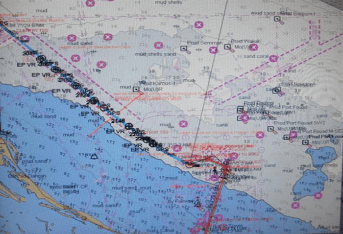
Bathymetry is the measurement of the depth of water in oceans, seas, or lakes. As with any other information, the reliability of the same is of prime importance. If a piece of information is read off of a chart, it is important to know that research that has preceded it so as to ascertain the authenticity of the obtained data. The ZOC diagram does exactly, helping the OOW to determine if the data obtained and applied towards navigation can be relied upon without any doubt. Any OOW will truly understand the importance of correct information that might be necessary when carrying out the ‘Planning’ aspect of the voyage which is where the ZOC comes into play.

While some areas tend to be very well surveyed, with the date of the survey carried out holding equal importance, some aren’t surveyed as thoroughly causing discrepancies in the reliability of the reading. Areas that are used for frequent commercial usage are naturally surveyed to a higher level of accuracy.
To understand the ZOC better, let us discuss the various aspects of the survey used to determine the category of ZOC.
- Position Accuracy: Position accuracy refers to the horizontal accuracy of a depth or feature. Quite self-explanatory, position accuracy gives the OOW a better understanding of the position at which the survey was made
- Depth Accuracy: While not in order of importance, for the purposes of understanding, we can say that the depth accuracy holds extreme importance to determine the UKC and thereby minimise the risk of grounding, smelling the ground, bank/canal effect, squat etc. Depth accuracy refers to the vertical accuracy of recorded depths.
- Seafloor Coverage: This gives us an idea of the extent of the area that was used to obtain said data and automatically indicates its umpteen importance. Obviously, the wider area covered with a higher frequency of data taken will help ascertain the reliability of the bathymetric data.
- Survey Characteristics: This section in the ZOC diagram gives out any specific information pertaining to the specific category of the data. For example, in category A1 (explained later) it may be mentioned that the data was obtained with the best possible survey and accuracy using a DGPS as well as LOP
The ZOC diagram, the details of such a survey, including the date of a survey can be categorised under the following as per its level of accuracy (A1 being the most accurate/highest):
Category A1
This is the highest level of accuracy on a nautical chart (whether paper of ENC). The above-mentioned position and depth accuracy, as well as seafloor coverage, has been verified with the best possible level of accuracy. For example, for the position accuracy in A1, the data is accurate up to ± 5 m + 5% depth.
[the_ad id=’173168′]
Category A2
Second to A1, an easy understanding of the same can be via the example of position accuracy which is +/- 20m
Category B
In this case, the full area search is not carried out. Uncharted features, hazardous to surface navigation are not expected but may exist. For example, position accuracy +/- 50m
Category C
Depth anomalies can be expected in this category. Position accuracy +/- 500m
Category D
Category D is worse than C which means it cannot be trusted and large anomalies in the depth can be expected
Category U
This is the unassessed category which means that the quality of the bathymetric data is not yet assessed
So as we can see, when planning a voyage, it is important to refer to the ZOC category displayed on the part of the chart (in the case of ENC, ZOC can be turned on or off) to ascertain the level of precaution to be taken when executing the passage plan. In the case of lower accuracy, all the aids to navigation must be put in use to ensure that vessel is not affected by the legitimacy of the data for that area. Failing this reference, it is possible that a vessel determines a certain depth in an area which might be a reading lower than the actual depth, leading to the ship grounding. The specifics of the ZOC can be further delved into with the following links to get an in-depth explanation for the same.
Zone of Confidence – MySailing.com
Admiralty – Zones of Confidence
The exact specifications of the associated accuracies for a certain category can be found from this Admiralty link:
To sum it up, ZOC forms an integral part of the voyage plan and should be referred to so as to avoid any undue mishaps.
Disclaimer: The views mentioned above are of the author only. Data and charts, if used, in the article have been sourced from available information and have not been authenticated by any statutory authority. The author and Marine Insight do not claim it to be accurate nor accept any responsibility for the same. The views constitute only the opinions and do not constitute any guidelines or recommendation on any course of action to be followed by the reader.
The article or images cannot be reproduced, copied, shared or used in any form without the permission of the author and Marine Insight.
Do you have info to share with us ? Suggest a correction

About Author
Shilavadra Bhattacharjee is a shipbroker with a background in commercial operations after having sailed onboard as a Third Officer. His interests primarily lie in the energy sector, books and travelling.
Latest Marine Navigation Articles You Would Like:


Subscribe To Our Newsletters
By subscribing, you agree to our Privacy Policy and may receive occasional deal communications; you can unsubscribe anytime.
When planning a voyage and calculating UKC you shoud cinsider ZOC. As far A, B and C is clear you include ZOC to UKC calculation then D which is worse than C so how you consider this? How much is worse than C? 🙂
when we read category B +/- 50m. when we must use +50m and when -50m. ?