10 Amazing Facts About The Aral Sea
The Aral Sea is a shallow, large brackish lake concealed in remote deserts between two countries.
The Aral Sea gets its water from two main rivers, and this has been supposedly for thousands of years. The water volume gets balanced by a natural equilibrium between inflow and evaporation.
It is said that the Aral Sea used to be as huge as West Virginia and had more water than Lake Huron and Lake Erie. In the 1960s, it continued to shrink and had vastly dried up by the 2010s.
The name “Aral sea” somewhat translates to “the Sea of Islands”, referring to several islands that surround their waters. In the languages of Mongolian and Turkic, Aral means island, archipelago.
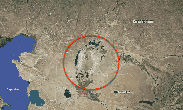
Uzbekistan and areas of Turkmenistan, Tajikistan, Kazakhstan, Afghanistan, Kyrgyzstan, and Iran together form the Aral Sea drainage basin.
This waterbody has tremendous historical and geographical importance.
Let’s take a look at ten interesting Aral Sea facts in this article.
1. The Aral Sea is situated between mainly two countries and fed by two rivers
Located in Central Asia, this inimitable Sea is between Kazakhstan and Uzbekistan. In the north, lies the regions of Aktobe and Kyzylorda Regions in Kazakhstan, and in the south, it connects its borders with Karakalpakstan, which is in Uzbekistan.
Water supplies in this area consist of groundwater and renewable surfaces. The Amudarya in the Southern Region and Syrdarya in the Northern Region are the two major river basins in the Aral Sea.
The Aral Sea gets its water from these two rivers, which largely depends on melted snow, thus maximizing its quantity in summer. Such accessibility is very suitable for the use of river water for irrigation.
2. Once, it was the fourth-largest lake ever to exist
With an area-span of 68,000 square kilometres, it was once one of the biggest lakes, which started dwindling in the nineteen sixties. The rivers which supplied water were used up for irrigation by Soviet irrigation schemes.
As stated by the World Bank, the sea level has fallen by sixteen meters. Soviet architects designed a network of irrigation canals in the 1960s to divert their waters into Uzbekistan and Turkmenistan cotton fields, draining the Sea of its water.
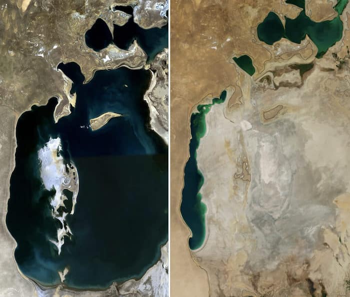
By 1997, the water had lessened to 10 per cent of its genuine limit, breaking into four lakes: the eastern and western bowls of the once a lot greater South Aral Sea, the North Aral Sea, and the go-between Barsakelmes Lake.
3. The Aral Sea can’t discharge its waters into any seas or rivers
It has its system of internal drainage. One of the most interesting Aral Sea facts is, it is an endorheic basin.
An endorheic basin is a drainage basin that usually holds water and requires zero drainage to other natural water sources, such as rivers or oceans but often converges into permanent or seasonal lakes or swamps that balance through evaporation. They are also known as closed or terminal basins or networks or basins for internal drainage.
4. There was once a fishing community
The Aral Sea had plenty of fish supplies and a busy shipping community, ranging from its northern port of Aralsk in Kazakhstan to the Amu Darya river ports, some as distant as Tajikistan. But it was all going to shift.
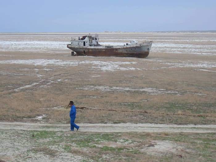
The consequences of changes due to irrigation were soon to be felt by the Aral Sea and the adjoining Central Asia tract. Degradation spreading to the whole Aral Sea basin happened by mismanagement of land and water supplies. This impacted the production of fish and caused high alkalinity and pollution with heavy sand storms.
According to the World Bank, freshwater sources have decreased, and public health issues have increased. The once-thriving fishing business in the area got destroyed, causing unemployment and economic distress.
5. It is said that The Government is mainly responsible for the demise of the Aral Sea
It is said that Khrushchev led the Soviet Government in the nineteen fifties, deprived the Aral Sea of its two water sources by establishing a program to promote agriculture and especially cotton. And that immediately resulted in less water that was arriving at the Aral Sea.
All of this water was getting redirected into channels, which resulted in a decrease in the Aral sea supply. However, most of it (25% – 75%) was getting absorbed by the desert and explicitly squandered.
From the sixties, the level of water in the Aral Sea began radically diminishing. In typical situations, the Aral gets about 20% of its water supply through precipitation, and the remaining is conveyed to it by the Amu Darya and the Syr Darya streams.
The facts about the Aral sea say that the change in the rivers’ direction is at the root of the imbalance that made the ocean gradually dry up during the last forty years.
6. The Sea Area is supposedly one of the poorest regions of the oil production province
At least a fifth of its population lives below the poverty line, and according to official estimates, the average monthly wage is three times lower than that of the financial capital of Kazakhstan, Almaty.
One of the interesting Aral Sea facts to look at is the lifespan of the people. The life expectancy rate is just sixty-six years, compared to seventy in Almaty. The increased salinity and mineralization of water sources, the continued use, and the prevalence of industrial chemicals are the causes of human health problems in the Aral Sea region.
The heavy application of fertilizers, herbicides, pesticides, and defoliants to cotton fields has caused these chemicals to continue to wash downstream. And this accumulated in the immediate Aral Sea area of the environment and food chain and contaminated them.
7. There is a high salt level in the Aral Sea
Did you know that this river’s salinity level was ten grams per litre earlier, and it is a hundred grams per litre now? It is one of the most interesting Aral Sea facts. The region’s drinking water contains four times more salt per litre than the World Health Organization’s prescribed limit.
At present, approx. 200000 tons of salt and sand are transported every day by the wind from the Aral Sea area and dumped within a range of 300 km. Salt contamination reduces the land available for planting, damages pastures, and causes a lack of livestock forage.
The livestock population in the region has become very low. Therefore, a decree to reduce their slaughter for food was implemented by the government.
8. The Aral Sea and its nearby areas have experienced rapid climate changes in recent years
It is one of the most saddening facts about the Aral sea. The drying of the Aral Sea also resulted in the adjustment in the Sea Surface Temperature. The Sea surface temperature in summer is increasing, while the temperature in winter has been diminishing.
Before the drying up period, the Aral Sea directed the climate by mellowing Siberian breezes in the colder time of year and cooling the zone in the late summer. In the time frame from 1960 to 2000, the temperature has expanded by 2°C to 6°C around the Aral Sea in the summer.
The air temperature has additionally diminished throughout the winter season. There is no sufficient surface area in the Aral Sea to disrupt the cold north winds. Nor does it gives the moisture it did once for the snowfall in mountains of nearby and distant areas.
Besides the consistently expanding temperature, salt and dust storms are covering the glaciers of the mountains nearby, which is resulting in a decline in the general volume of ice. The level of melting is more than twelve times the pace of the pre-cotton growing time. The glaciers continue to diminish at a fast rate.
9. In is believed that in the early 1990s, the Soviet Government set up a laboratory for bioweapons in the Aral Sea centre
If we write a book about all the interesting Aral Sea facts, this point would be somewhere at the front. A top-secret Soviet bioweapons laboratory was built in 1948 at the Vozrozhdeniya Island, in the middle of the Aral Sea.
Many agents, such as smallpox, anthrax, brucellosis, plague, and tularemia, were experimented on on the island. Most of the lethal disease-causing microorganisms have been buried. Even now, some of them (microorganisms) are still found.
The Soviet Union fell, and it got abandoned. Fortunately, the Kazakh Government has ensured the decontamination of the regions where microorganisms have been concealed.
10. The area near the Aral Sea experiences a lot of sand storms
The Aral Sea locale experienced desertification during the drying up period. The study of temperature is one of the interesting Aral sea facts. The drying up of the Aral Ocean extraordinarily expanded the quantity of salt and dust storms nearby.
Satellite pictures have uncovered that there are up to ten significant residue storms happening every year in the area, the majority of them occurring between the long periods of April and July. Previously, the force from the surface hosed the power of the north and north-east breezes.
The north-easterly winds presently collect the sand, salt, and residue, making sand storms. Salt and dust reached places as far as 500km away from the source. A portion of the salt even arrived at the developed soils, which demolished the cultivated lands far away from the Aral Ocean area.
The measure of salt eliminated was about forty-three million metric tons somewhere between nineteen sixty to nineteen eighty-four.
We looked at the lesser-known and some of the most interesting Aral sea facts. Now we are about to come across some of the questions that people generally ask. Through these questions, you will get to know more Aral sea facts that will leave you amazed.
1. How old is the Aral Sea?
Around the ending of the Neogene era (which persisted from about twenty-three to three million years ago), the depression was created. The Aral Sea facts state that the depression got overflowed with water during that process, a part of which came from the Syr Darya. The area appears to have dried up in the beginning and middle portion of the Pleistocene era (approximately 2.6 million to 11.7 thousand years ago). It was flooded again somewhere in the middle of the end of the Pleistocene and the beginning of the Holocene Epoch. It got water by the Amu Darya, which briefly shifted its path to the Aral Sea from the Caspian.
2. What is different about the Aral Sea?
Once upon a time, it was the fourth biggest lake to exist. In the early 1900s, it provided communities with a range of significant ecosystem resources. This included fishing stocks and conservation of the local water and soil fertility. However, From the 1960s onwards, the water level in the Aral Sea began to decrease rapidly.
3. Why is the Aral Sea known as a sea, even when it is not?
One of the unique Aral sea facts is that it is a lake. Until the 1970s, with sixty-eight thousand sq km in area, four hundred twenty kilometres in length, and two hundred eighty kilometres in width, it was so huge that it was called a sea. It had the presence of a thousand islands and is known as the Sea of Islands. It even has other names! It’s what the Arabs call Khwarazm or Khorezm. The people of Russia refer to it as Sinyeye More.
4. How big is the Aral Sea at present?
The Aral Sea has been evaporating and diminishing ever since the onset of irrigation, with no other significant water source. The lake’s area is twenty-five per cent of its previous size after fifty years, and it retains only 10 per cent of its actual water volume.
But the government has undertaken many policies and measures to bring back the water flow in the Aral sea. In 2005, the Dike Kokaral dam got finished.
By 2008, the water level had increased by twelve meters in five years. The salt content has decreased, and we can see fishes in adequate numbers to be viable for some fishing. As of 2008, The Northern Aral Sea had a maximum depth of 42 m (138 ft).
In this article, we had an insight into many interesting Aral sea facts. We even came across the saddening news of the slow demise of this vast lake.
However, the government is undertaking several projects for the restoration of this mighty lake. The recent positive effects include the increase in marine fauna, water level, and climatic changes.
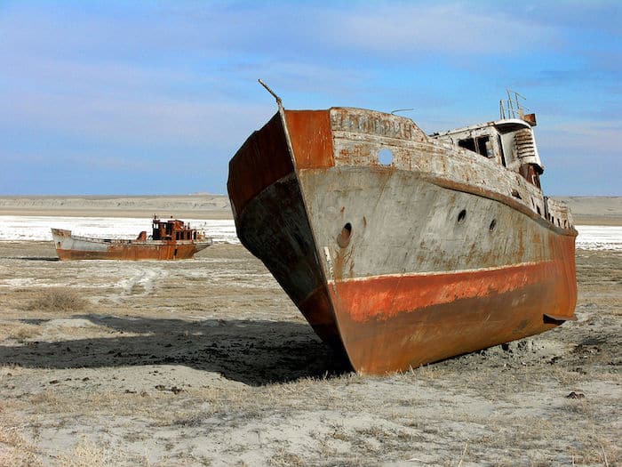
Perhaps more than technical fixes, a little foresight and patience in coping with nature are what we all need most. It was conveyed better by words painted on the rusting hull of an abandoned fishing boat lying in the desert, “Forgive us Aral, all of us. Please Come back.”
You may also like to read –
- 10 Facts About Northwest Passage
- 10 Interesting Facts About The Tasman Sea
- Aral Sea Disaster: Why One of the Biggest Inland Seas Dried Up?
Disclaimer :
The information on this website is for general purposes only. While efforts are made to ensure accuracy, we make no warranties of any kind regarding completeness, reliability, or suitability. Any reliance you place on such information is at your own risk. We are not liable for any loss or damage arising from the use of this website.
Related Posts
Disclaimer :
The information on this website is for general purposes only. While efforts are made to ensure accuracy, we make no warranties of any kind regarding completeness, reliability, or suitability. Any reliance you place on such information is at your own risk. We are not liable for any loss or damage arising from the use of this website.
Related Articles
Subscribe To Our Daily Newsletter
By subscribing, you agree to our Privacy Policy and may receive occasional deal communications; you can unsubscribe anytime.





BE THE FIRST TO COMMENT