

7 Best Handheld Marine GPS in 2024
Looking for a handheld marine GPS device for your next expedition? You have come to the right place.
The advent of technology has resulted in a vast improvement in navigation tools used at the sea. In the marine industry, one technological development that has pioneered navigation is the Global Positioning System (GPS). Although conventional GPS systems are connected to computers, furtherance in the technology has led to the innovation of handheld marine GPS.
There are many GPS manufacturing companies that create and market such as portable marine GPS. But then there are those few elite ones that not only market a portable GPS navigator but ensure that these navigators are the best amongst their technological peers.
What are handheld marine GPS and its uses?
A GPS handheld device is very important at sea in order to locate your exact place and also in events of some crisis.
A marine GPS handheld device can help seafarers guide their boats in coastal areas as well as deep seas. It also enables both commercial and recreational fishermen to locate fishes as many GPS devices some with fish finder feature.
So what are the best GPS handheld devices in the market? You would see that Garmin devices dominate the list, but that is also because they are the best in the field and make reliable devices you can rely on.
Pros and cons of marine handheld GPS
Pros –
- You can carry maps in a handheld device
- You can even know your altitude
- Handheld GPS is easy to use. You don’t need to be tech-savvy.
- Help you enhance your navigation skills
- Helps prevent dangers and in time of emergencies.
Cons –
- These are sometimes not rugged and can get damaged easily when dropped
- Some require maintenance
- Battery life can sometimes be an issue
- Expensive devices
Main Features of a GPS device
- Realtime tracking
- Trip history
- Alerts
- Anytime anywhere, access
- Geo-fencing
- Reports of historical events
- User-friendly interface
Mentioned in here are five best portable handheld marine GPS in the market today:
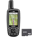
Garmin eTrex 20 x 65k has 240×320 pixels with a striking display that guarantees sharp pictures in direct daylight and stormy climate conditions.
The preloaded base guide is an additional feature that is highly useful.
It comes with a 3.7 GB of capacity to store your extra maps and sort out the maps any way you need. It is easy to locate and the GLONASS backing empowers high-accuracy and quick find in any event of an emergency
Pros:
- Sunlight readable 240×320 pixels display
- A decent size (up to 3.7 GBs of inward memory + microSD opening)
- Preloaded overall maps
- HotFix Satellite expectation and GLONASS support
Cons:
- Not all subtleties of maps are accessible
- Lack of manuals
- Does not accompany an extra SD card

- UPGRADED DISPLAY - Features a 2.2” 65K color sunglight readable display offering increased resolution (240 x 320 pixels)
- LOAD MORE MAPS - Large 3.7 GB of internal memory and microSD card slot lets you load a variety of maps, including TOPO 24K, HuntView, BlueChart g2, City Navigator NT and BirdsEye Satellite Imagery (subscription required)
- PRELOADED BASEMAP - Includes a worldwide basemap with shaded relief. Display size:1.4 x 1.7 inches
- KEEP YOUR FIX - With its high-sensitivity, WAAS-enabled GPS receiver, HotFix satellite prediction and GLONASS support, eTrex locates your position quickly and precisely and maintains its location even in heavy cover and deep canyons
- Included Components: Documentation
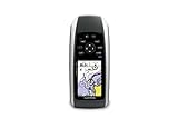
2. The Garmin Inreach Explorer+
These handheld GPS units are fundamental to adventures such as boaters, mountain dweller etc. The information from this powerful device enables clients to decide their area, altitude, and other significant data that are valuable in wayfinding. The Garmin Inreach Explorer+ has worldwide Iridium satellite inclusion, which permits 2-way informing utilizing content from virtually anyplace on the planet.
The device is furnished with an original SOS work, which can be activated to send message to 24/7 search and rescue monitoring centre. The unit enables your loved ones to keep a track of you. The device can be combined with cell phones, for example, mobile phones and PCs, utilizing the Earthmate application, which comes free with the device. This enables you to download maps, outlines, and aerial pictures.
Pros –
- The overall inclusion gave by the device’s Iridium satellite system association offers clients a chance to keep in contact with loved ones from anyplace.
- A barometric altimeter decides altitude just as scope and longitude.
Cons –
- The vast majority of this current device’s preloaded maps are US-based so that it won’t be as helpful outside of the nation.

- 100 percent global Iridium satellite coverage enables two way text messaging from anywhere (satellite subscription required)
- Trigger an interactive SOS to the 24/7 search and rescue monitoring center
- Track and share your location with family and friends. Water rating : IPX7. Battery : Rechargeable internal lithium ion
- Pair with mobile devices using the free earthmate app for access to downloadable maps, U.S. NOAA charts, color aerial imagery and more
- In reach explorerplus device adds preloaded Delorme topo maps with onscreen GPS routing plus built in digital compass, barometric altimeter and accelerometer
The daylight Readable 2.6 display helps with reading clear information, paying little respect to the hour of the day, sunlight, and climate conditions. It also comes with internal memory to store numerous maps in the inward memory of the device, without requiring a microSD card. The dual battery framework guarantees longer working hours, utilizing two batteries where you can transform one while the device is working and smart notifications – contains a temperature sensor, an altitude sensor, and accelerometer.
Pros –
- 16h of battery life
- Ability to charge the device while it is working.
- TOPO U.S. 100K + BirdsEye Satellite Imagery membership for nothing
- Wireless and Bluetooth support
- 3-pivot compass with barometric altimeter
Cons:
- Pricy
- A remote association requires a solid cell phone GSM signal
- Lack of complete manual
- Occasional GPS signal interruption
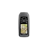
This marine handheld unit is an absolute necessity have device for any individual who needs to monitor courses while surfing water. The unit incorporates a splendid 2.6-inch display with high affectability GPS recipient and implicit base guide. Other significant highlights are 1.7 GB inward memory, information stockpiling, and microSD card space.
A decent quality marine GPS tracker, GPSMAP 78sc is incredibly convenient when at sea. High quality and sturdiness are excellent advantages provided by this GPS tracker.
Pros:
- GPSMAP 78sc, is intended to last more. Made out of reliable and robust materials
- Value for money
- A large portion of the marine GPS trackers out there comes at a substantial cost. But the GPSMAP 78sc is valued in the unobtrusive range to suit the spending limit of all classes of purchasers
- A robust 1-year guarantee upholds the GPSMAP 78sc. If something turns out badly with the device, you can call the seller and have the issues fixed without paying anything extra.
Cons:
- A few people confronted issues with the utilization of the device. In any case, that is not an issue. A little consideration on your end can resolve this minor issue.
- Marine-friendly handheld with high-sensitivity GPS receiver and 2.6-inch color TFT display
- Perfect for boating/watersports--waterproof to IPX7 standards; floats in water
- Built-in BlueChart g2 U.S./Bahamas coastal charts with shorelines, depth contours, navaids, harbors, marinas, and more
- Built-in 3-axis tilt-compensated electronic compass and barometric altimeter for heading/altitude/weather
- Share your waypoints, tracks, routes and geocaches wirelessly with other compatible device user
The Garmin GPSMAP 78S comes with a high sensitivity GPS receiver with 2.6 inch color display. This device floats in water if gone overboard and thus is perfect of sailors.
With built-in BlueChart g2 U.S./Bahamas coastal charts with shorelines, depth contours, navaids, harbors, marinas, and more, it is perfect of smooth navigation.
Pros:
- Floats in water
- Adding maps to microSD card is easy
- Can share your waypoints, tracks, routes and geocaches wirelessly with other compatible device users
Cons:
- Vision can sometimes get blurry
- Smaller screen size
- Only US Maps
- 2.6-inch TFT LCD display. Display size-1.43 x 2.15 inches. 2.6 inch diagonal
- Worldwide shaded relief basemap; microSD card slot for optional mapping
- 3-Axis compass & barometric altimeter
- Floats, buoyant
- Built-in 3-axis electronic compass; Barometric altimeter
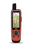
The Garmin GPS 86Sci though a bit pricey is one of the finest marine handheld devices in the market. It is a water-resistant and floating device, with a sunlight-readable 3-inch display.
Enabled with satellite communication, it comes with two-way text messaging via the 100% Global Iridium satellite network.
It also comes with a 24×7 SOS service.
Pros:
- Brilliant menu arrangement; quick access to highlights
- Splendid screen
- Preloaded charts
- Wireless connectivity
Cons:
- Doesn’t work with standard mounts

- Water-resistant, floating design, sunlight-visible 3” display and button operation provide ease of use on the water
- Stream boat data from compatible chartplotters and instruments to consolidate your marine system information
- Preloaded bluechart G3 coastal charts include the best of Garmin and Navionics data
- Stay in touch with in reach satellite communication and two-way text messaging via the 100% Global Iridium satellite network (satellite subscription required)
- Functions as a remote control for convenient operation of your Garmin autopilot and Fusion Marine products; to activate, download free apps from our Connect IQ store
This premium marine handheld GPS device comes with 3″ sunlight-readable display along with amazing battery backup. It is a water-resistant and floating device with two-way text messaging via the 100% Global Iridium satellite network.
With worked in inReach satellite innovation and extra assistance options¹, GPSMAP 86i encourages you to keep in contact with your loved ones universally.
Pros:
- Water-safe, floating design
- Keep in contact with two-way content informing using the 100% worldwide Iridium® satellite system (satellite membership required)
Cons:
- Pricey
- Water-resistant, floating design, sunlight-visible 3” display and button operation provide ease of use on the water
- Stream boat data from compatible chartplotters and instruments to consolidate your marine system information
- Stay in touch from anywhere with in reach satellite communication and two-way text messaging via the 100% Global Iridium satellite network
- Functions as a remote control for convenient operation of your Garmin autopilot and Fusion Marine products; to activate, download free apps from our Connect IQ store
- Supports optional bluechart G3 charts
Each of these best portable marine handheld GPS systems provides the ultimate user satisfaction and features for a safe voyage, unlike any other portable marine GPS.
You may also like to read – An Introduction to Fluxgate Compass
Disclaimer: The authors’ views expressed in this article do not necessarily reflect the views of Marine Insight. Data and charts, if used, in the article have been sourced from available information and have not been authenticated by any statutory authority. The author and Marine Insight do not claim it to be accurate nor accept any responsibility for the same. The views constitute only the opinions and do not constitute any guidelines or recommendation on any course of action to be followed by the reader.
The article or images cannot be reproduced, copied, shared or used in any form without the permission of the author and Marine Insight.
We earn a commission if you make a purchase through an affiliate link, at no additional cost to you.
Do you have info to share with us ? Suggest a correction
Latest Marine Navigation Articles You Would Like:


Subscribe To Our Newsletters
By subscribing, you agree to our Privacy Policy and may receive occasional deal communications; you can unsubscribe anytime.
Web Stories


where is my shipping
We are required a quotation of Hand Held Marine GPS qty- 20 Nos for supply in Bangladesh coast Guard.
Garmin 276c
Garmin 76csx price please
I want info regarding the “79SC”