

30 Types of Navigation Equipment and Resources Used Onboard Modern Ships
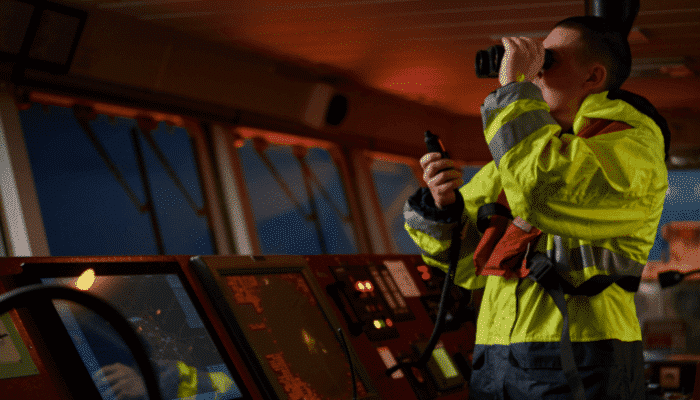
Gone are the days when a ship navigation officer had to take help of unconventional ways to plan and navigate a voyage at sea. Today, a ship officer has myriad of marine navigation equipment which makes his life a lot simpler, thanks to the advancement in technology. Moreover, present-day seafarers are trained so as to know the functioning and operation of all modern day navigational equipment that has made the journey at sea smoother and safer.
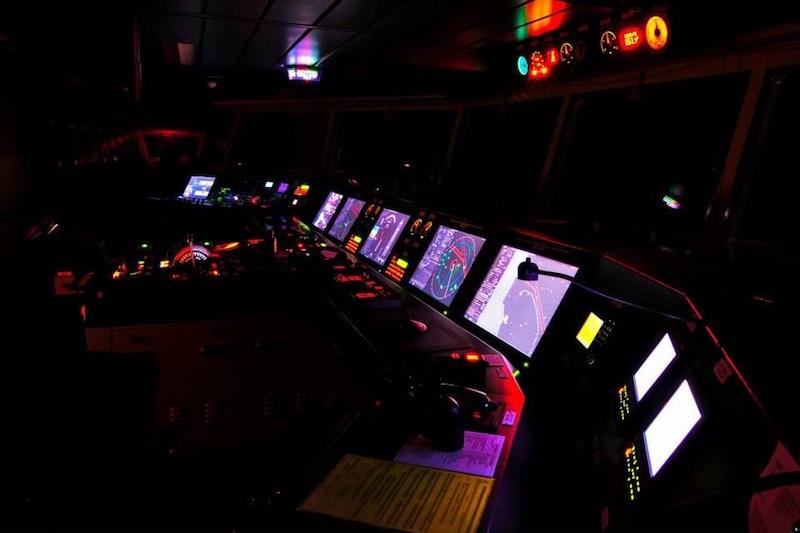
With modern day facilities and automation, a ship today has several advanced navigation equipment systems which give accurate data for the voyage.
Download Practical Maritime eBooks With Amazing Bonuses:
Here are a few fantastic ebooks to get important maritime information in the next couple of minutes!
Herein, we have enlisted 30 types of navigational equipment, both old and new, which are present on all merchant ships.
1. Gyro Compass
It is used for finding the right direction. Unlike magnetic compass, gyro compass is not hampered by an external magnetic field. It is used to find the correct North Position, which is also the earth’s rotational axis to provide a stable directional source. Its repeater system must be present in the steering platform for emergency steering.
Read more about Gyro Compass here
Related Read: Top 3 Free Marine Compass Apps for Android Smart Phones
2. Radar
The seagoing vessels depend on S-band and X-band frequency radar system for navigation as it can detect targets and display the information on the screen such as the distance of the ship from land, any floating objects (an island, rocks, iceberg etc.), other vessels, and obstacles to avoid a collision. It is a rotating antenna which discovers the surrounding area of the ship.
Read more about ECDIS here.
Related Read: 15 Things To Consider While Using Radar On Ships
3. Magnetic Compass
The magnetic compass work in conjunction with the magnetic field of the earth and is the essential means of the direction indicating device. It is used to get a planned course for the voyage. This ship navigation equipment is usually fitted at the centre line of the ship on the monkey island. A transmitting magnetic type compass is fitted so that the output can be displayed in the bridge panel.
Related Read: What is a Binnacle On Ships?
4. Auto Pilot
The ship bridge layout is filled with equipment and tools used for navigation. The autopilot is considered to be one of the most effective bridge navigational equipment as it assists the human operator in controlling the ship by keeping the steering in autopilot, which allows them to concentrate on broad aspects of the operation.
It is a combination of hydraulic, mechanical, and electrical system and is used to control the ship’s steering system from a remote location (Navigation bridge).
Related Read: 10 Things to Consider While Using Auto-Pilot System on Ships
5. ARPA
Automatic Radar Plotting Aid displays the position of a ship and other vessels nearby. The radar displays the position of the ships in the vicinity and selects the course for the vessel by avoiding any kind of collision.
This bridge navigational equipment constantly monitors the ship’s surrounding and automatically acquires the number of targets, in this case; ships, boats, stationary or floating objects etc., and plot their speeds and courses respectively. It also presents them as vectors on the display screen and constantly update the parameters with each turn of the antenna by calculating their nearest points of approach to own ship and also the time before this will occur.
6. Automatic Tracking Aid
Just like ARPA, automatic tracking aid displays the information on tracked targets in graphic and numeric to generate a planned layout for a safer and collision-free course.
Usually, A large size target measuring 800 m or more in the circumference is considered as a landmass and not tracked. Echoes less than 800 m are deemed as targets to be tracked.
Related Read: 10 Important Things To Do During Ship Collision Accident
7. Speed & Distance Log Device
This bridge equipment on a ship is used to measure the speed and the distance travelled by a ship from a set point. By calculating the same, ETA of the ship is adjusted or given to the port authority and agent.
8. Echo Sounder
There are many modern ship navigation tools present on ship and echo sounder is one of the instruments which has been in the play from almost 100 years now. It is used to measure the depth of the water below the ship’s bottom using sound waves which work on the principle of transmission of sound waves and an audio pulse which will bounce off a reflecting layer, returning as an echo to the source.
9. Electronic Chart Display Information System
ECDIS is a development in the navigational chart system used in naval vessels and ships. With the use of the electronic navigation equipment, it has become easier for a ship’s navigating crew to pinpoint locations, and attaining directions are easier than before.
Read more about ECDIS here.
Related Read: Pros and Cons of ECDIS Or Paperless Navigation Of Ships
10. Automatic Identification system
AIS is also among the types of a navigation system which helps to pinpoint the location and other navigational statistics of ships. AIS uses VHF radio channels as transmitters and receivers to send and receive messages between ships which endeavours to fulfil a lot of responsibilities.
As per the regulation enforced by The International Maritime Organisation (IMO), all passengers’ vessels and commercial ships over 299 Gross Tonnage (GT) sailing in the international to carry a Class A AIS transponder.
Read more about AIS here.
Related Read: Download: The Definitive AIS Handbook
11. Long Range Tracking and Identification (LRIT) System
LRIT is an international tracking and identification system incorporated by the IMO under its SOLAS convention to ensure a thorough tracking system for ships of 300 gross tons and above which are on international voyages across the world. This maritime equipment is fitted to improve the maritime domain awareness.
Read more about LRIT here.
12. Rudder Angle Indicator
Rudder angle indicator, as the name indicates, provides the angle of the rudder. The display is provided on the navigation bridge equipment console so that the ship navigation officer can control the rate of turn and rudder angle of the ship. The indication is also provided in the bridge wing and engine control room.
Related Read: How Does A Rudder Help In Turning A Ship?
13. Voyage Data Recorder
A VDR or voyage data recorder is a crucial instrument among the ship navigation equipment list which is installed on a ship to continuously record vital information related to the operation of a vessel. It contains a voice recording system for a period of at least the last 12 hours. This recording is recovered and made use of for investigation in events of accidents. The importance of VDR is similar to a “black box” installed on an airplane.
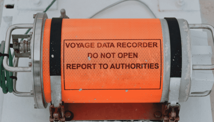
Read more about VDR here.
14. Rate of turn indicator
This navigational tool indicates how fast the ship is turning at a steady rate (useful during pilotage and manoeuvring), normally shown as a number of degrees turned. The rate a ship is turning is measured in degrees per minute. This essential tool assists a coxswain in steering a course safely.
15. GPS Receiver
A Global Positioning System (GPS) receiver is a display system used to show the ship’s location with the help of Global positioning satellite in the earth’s orbit.
With the record of the ship’s positions, the speed, course, and the time is taken to cover the distance between “two marked positions” can be calculated.
Related read: 5 Best Handheld Portable Marine GPS Devices
16. Sound Reception System
This acoustic system is required for a ship with a fully enclosed type bridge. It enables the navigating officer inside the cabin to listen to the sound signals (such as fog or ship’s horn) from other ships in the vicinity. This is fitted in ships bridge equipment console and helps the navigating officer to conduct the look-out duty as per the International Regulations for Preventing Collisions at Sea.
Related read: 10 Important Points Ship’s OOW Should Consider During Restricted Visibility
17. Navigational Lights
All boats – whether big or small are required to have night lights as a part of the navigation systems. This system was introduced in the year 1838 by the United States and then was followed by the United Kingdom in 1849. In the year 1889, the International Maritime Conference was established by the United States to establish proper guidelines to prevent marine accidents. In the year 1897, these rules were officially adopted internationally. The navigation lights are one of the most critical navigation equipment needed for sailing in high seas as it enables self vessel being clearly visible to other ships in the vicinity.
Read more about navigation lights here.
Related read: How Maintenance of Navigation Lights is Done On Ships?
18. Ship Whistle
A ship’s horn is known as a whistle and it is generally provided in duplicate. One is driven by air and the other is electrically operated. The whistle should be both manually and electrically operational from the bridge.
Among different instruments used in difficult navigation such as bad weather, fog, poor visibility, high traffic etc., the ship’s whistle or horn helps in alerting the nearby vessels.
During an emergency, the horn is used to notify and alert the ship’s crew and other vessels nearby.
19. Daylight Signalling Lamp
They are light-signalling devices used for emergency signalling in the day time (and can also be used during the night). Like other emergency ship instruments, the energy source for the lamp is not solely dependent on the ship’s main power supply. Also, the lamp enclosure should be weather and seawater- proof material.
20. Pilot Card
It is an informative booklet provided to the ship’s pilot. It consists of the dimension, draught, turning circle, manoeuvring, propulsion equipment and other navigation tools and instruments list of the vessel for safe manoeuvring.
Related Read: What Are The Duties of Officer On Watch When Pilot is On Board Ship?
21. Voyage Plan
A voyage Plan must be present onboard for referring past voyage plans or planning a future voyage. Among the different aids to navigation carried on a ship, a voyage plan is a tool for the deck officer to ensure the safety of the ship from a commercial and legal perspective too. It is prepared by gathering different information such as weather, meteorological, ship’s current and future cargo data, other navigational data etc.

Read more about Voyage Plan here
22. Forecastle Bell
It is used to mark the presence of the ship in fog or bad weather and sound the alarm in case of an emergency, along with the ship’s main horn or whistle.
Related Read: What to do When Ship Encounters Rough Weather?
23. Manoeuvring Booklet
In this booklet, the performance of the propulsion plant and the ship during manoeuvring in different weathers and situations is recorded for quick reference. The important content of the manoeuvring booklet are:
- Ships General description
- Manoeuvring characteristics in deep water
- Stopping and speed control characteristics in deep water
- Manoeuvring characteristics in shallow water
- Manoeuvring characteristics in wind
- Manoeuvring characteristics at low speed
- Additional information
Related Read: Understanding Different Types Of Manoeuvres of a Vessel
24. Black Ball Shape
It is a day time signalling shape used to determine the characteristics of the vessel with a different arrangement of ball shapes. For e.g. a vessel at anchor will show a black ball at the foremost end of the forecastle and a ship not under command shows two black balls in a vertical line on her highest mast.
Related Read: Responsibilities Of Deck Officer During Anchoring Operation
25. Record of Navigation Activities
All the navigational activities which are performed by the ship’s officers and crew using different navigation equipment on the bridge must be recorded and kept on board for ready reference. This is mandatory and the most important log book.
Related Read: Different Entries To Be Made In Bridge Log Book of The Ship
26. Record of Maintenance of Navigational Equipment
The hard copy of all the ship navigation system and equipment list must be present as records onboard ships for ready reference of port and regulatory authorities and must be signed by master and duty officers of the ship.
Related Read: Daily, Monthly And Weekly Tests Of GMDSS Equipment On Board Ships
27. Wheelhouse Posters
Present in the Navigation bridge, it displays detailed information of manoeuvring characteristics of the ship including turning circle, stopping and manoeuvring characteristics of the vessel.
28. Transmitting Heading Devise
Transmitting Heading Devise or THD is an electronic device which is used to display the information of the vessel’s true heading. The THDs compliance information is provided in chapter V of the SOLAS Convention.
29. Black Diamond Shape
When the ship is being towed or when a vessel is unable to manoeuvres on itself, a black diamond shape is shown during the day time.
Related Read: Preparations For Emergency Towing Of Ship – 10 Important Points
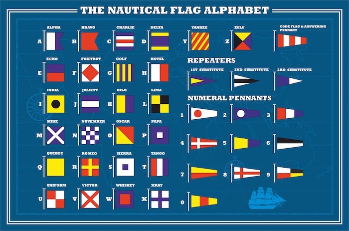
30. Ship Flags
Various types of ship flags with different colours and signs are used to indicate a navigation ship’s position. Signal flags are they are commonly known, have been used since the ancient times and are still used on all vessels.
These are the different bridge equipment and their uses which are installed on the ship to assist the deck officer for navigating the vessel safely. If we missed any equipment or you want to add more to the list, please comment below.
Related Read: Understanding Nautical Flag Etiquettes
Top 10 Celestial Navigation Books
An Introduction to Fluxgate Compass
Disclaimer: The authors’ views expressed in this article do not necessarily reflect the views of Marine Insight. Data and charts, if used, in the article have been sourced from available information and have not been authenticated by any statutory authority. The author and Marine Insight do not claim it to be accurate nor accept any responsibility for the same. The views constitute only the opinions and do not constitute any guidelines or recommendation on any course of action to be followed by the reader.
The article or images cannot be reproduced, copied, shared or used in any form without the permission of the author and Marine Insight.
Do you have info to share with us ? Suggest a correction
Latest Marine Navigation Articles You Would Like:


Subscribe To Our Newsletters
By subscribing, you agree to our Privacy Policy and may receive occasional deal communications; you can unsubscribe anytime.
Thanx mate
it was a short and sweet useful info.
Appreciate ur work.
this is educating for the beginners. i guess to make this site a complete marine site, more diagrams of navigational equipment and their function should be uploaded.
good work
This page is helping many maritime student to know the fundamentals of marine navigation, especially student of Maritime Management Technology (MMT). Federal University Of Technology, Owerri (FUTO), In Nigeria.
I love this page, kudos to the owner..!
very informative n interesting website for student and enthuisist
This is really navigation made easy….recommended for every navigator. A must read for every seafarers…i have really learnt enough.
i really like this pages, this information helps me a lot. i am a BSMT student.
nice site but needs full navigating equipment’s update for us maritime students in Nigeria, especially for our students in federal college of fisheries and marine technology that does not have a vessel to show and teach us practical things about ships
Very usefull
DEAR Sir
IF YOU HAVE ANY MARINE NAVIGATION REQUIPMENT PLEASE INFORM US
Gud and usefull
This remains my best maritime website ever seen very rich and educating, i have recommended it to a number of my friends in Nigeria and they were glad indeed. The marine combo pack has widen my knowledge as a young practitioner and i now stand tall among my colleaques. kudos to you for a job welldone.Love you all
Thank you so much for spreading the word. Let’s know if you would want to read anything specific at info@marineinsight.com . All the best!
realy i appreciate this website. thanx he given me a lot experience about navigation
Thkx for dishing out the entics of today nav equipment for modern seafarer
Thkx for dishing out the entics of today nav equipment for modern seafarers
very informative n interesting website for student and enthuisist
So much very good
Very useful site for marine inventories
Thank you!
Very informativ & interesting websit
very important side for marine navigation
no help.
Thang you so much all
I learned a lot of navigation type
And I like it.
Thanks.
Thanks for present info.
Can you guide me to such manufacturers who are providing all in one navigational equipment including but not limited to, gyro, compass, echo sounder, GPS, radar and displaying all functions on one screen?
Thanks and looking for response to my query.
Its quite helpful to all those involved in marine duties,am frm the nigerian navy , on my radar plotter course 1 final yaer
This information is very useful for me.i preparing for AU seamanship exam.thanku
Thank you very much.
its really great system i like this
Thanks so muc for desining, this sites ,was very useful for me , because I am employee of marin company and I need to know about all of necessary devices a ship. Sanam from Iran
Very nice
It will help us to those study inBSMT.please inform us a new update.
Can anyone give any insight on what are CRITICAL Navigation Equipment as required by Offshore Vessel Management and Self Assessment (OVMSA)? Thank you.
Just to thank you, atleast l learn types of Equipment inside the Ship. I really enjoy reading.
Marineinsight is the best site to give information about various shipping equipments in marine fields. It is very useful to all people who related to marine society.
@Papu: Thank you so much for the appreciation and support. ??
What is the most reliable navigational Equipment?
it help me to defend my log book.
thanks al lot
thanks for this information
@Zubair: Cheers mate ????
Hi there!
I think you forgot the palindrome (palinorium).
On my years it was an important equipment.
Good Job.
Allot of information, for real I appreciate
@Aguma: Thanks a lot. Glad the information is useful.
Great Knowledge one should better be stuck on it
Navy Captain Onana Essomba /cameroon Navy
What of Navtex, Inmarsat,Binacular,sextant.
Emekpa Prosper from Nigeria.
Thanks for spreading your knowledge 👍
I want to navigation ebook because I am a seaman
Hey Deepak – You can check our digital guides for the same – https://learn.marineinsight.com/eBooks/e-deck-department/
very nice but you didnt mention at GIS and MDA