

Aral Sea Disaster: Why One of the Biggest Inland Seas Dried Up?
It was shocking when researchers earlier this year revealed a river that originated from one of the largest glaciers in Canada abruptly disappeared over four days in 2016.
The vanishing of the Slims River, however, was the result of global warming as the intense melting of the glacier led the river to redirect its waters to the Gulf of Alaska.
However, the Aral Sea, similar to the river in Canada, was known as “one of the planet’s worst environmental disasters” because of human interventions rather than geographical and climate changes.
Once the world’s fourth largest lake, it has been called a sea due to its size. However, it shrunk by more than 90 percent over fifty years ago, mainly because of the rerouting of its source rivers.
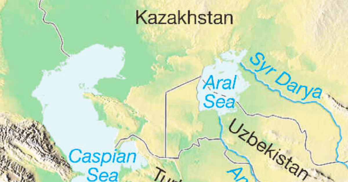
Location and History of Aral Sea
Located between Kazakhstan in the north and Karakalpakstan, an independent area of Uzbekistan, in the south lies the Aral Sea. The Sea of Islands referred to more than 1500 islands as a wonder.
The two rivers that feed the Aral Sea are the Amu Darya and Syr Darya rivers. The first one reaches the body of water through the South, while the second goes through the North.
If the map of a Greek Scholar Claudius is anything to go by, then the Caspian and the Aral Sea were joined and formed a vast inland sea earlier.
However, according to Geographer Dr Nick Middleton, the Amu Darya did not flow to create the Aral Sea until the beginning of the Holocene, and it was flowing into the Caspian Sea until then. He also noted that the Syr Darya formed a large lake called the Mynbulak Depression in the Kyzyl Kum during the Pliocene.
The Aral Sea area is characterised by a desert-continental climate, hot summers, cold winters and scanty rainfall, only 100 mm annually.
Beginning of the catastrophe
According to historical documents, the Aral Sea region was inhabited by desert nomads and used to support a booming fishing industry.
In the 20th century, the Aral Sea was reported to be the world’s fourth-largest inland water body, with an approximate area of 68,000 sq. km. The rivers that fed the lake also supplied nearby towns, giving birth to the historic Silk Route.
However, the Aral Sea Disaster started taking shape only in the 1930s. As agricultural land was increased to enhance the flourishing cotton industry further, water consumption also increased dramatically.
Following the Soviet government’s plan to irrigate the desert by undertaking a diversion project to cultivate rice, melons, cereals, and cotton, many irrigational dams and canals were built on the arteries of the Aral Sea.
Moreover, the poorly built channels also led to severe water waste. Water wastage from the largest canal in Central Asia, the Qaraqum Canal, was reportedly 30 to 70 per cent.
In the 1960s, the water level in the Aral Sea drastically dropped as up to 60 cubic kilometres of water was diverted to the farmlands instead of the sea. The amount of redirected water increased heavily as cotton production in the farmlands doubled between 1960 and 2000.
As a result, the sea shrank at a maximum pace, at an average of 20cm between 1961 and 1970, 50-60cm in the 1970s, and 80–90cm in the 1980s. The latest data reveals that the water level in the Aral Sea drops by an average of 31-35 inches yearly.
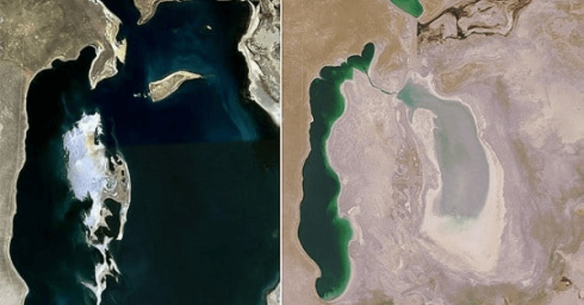
Along with the reduction in water level, the sea’s surface area also shrank by about 60% between 1960 and 1998. While the Aral Sea had an area of around 68,000 km2 in 1960, the area recorded in 1998 was 28,687 km2.
During this period, its position among the largest lakes dropped from fourth to eighth. In 1987, the continuous shrinkage divided the Aral Sea into two parts: the North Aral Sea, which was the more minor part (known as the Lesser Sea), and the South Aral Sea, which became the larger part ( the Greater Sea).
Damaged Ecosystem and Human Health Hazard
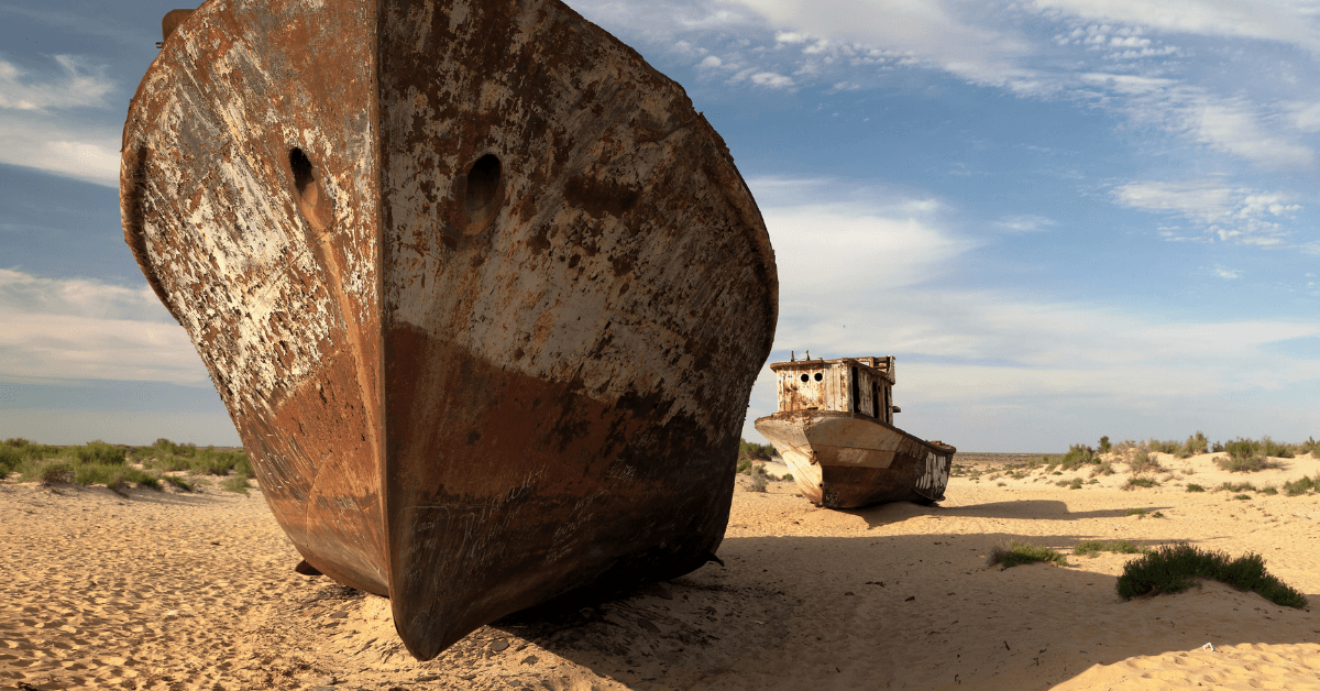
Despite geographical changes, this disaster also impacted the flourishing fishing economy. The fishing industry that once reportedly produced one-sixth of the catch in the Soviet Union and employed around 40,000 has been destroyed. The use of pesticides also increased at an alarming rate. With the gradual increase of industrialization and the high water level dropping, the Relic Sea became too salty even for aquatic animals to survive.
Marine life suffered greatly, and the fishing industry gradually reached an all-time low, one of the major consequences of the dying Aral Sea. The abandoned fishing trawlers in the sandy wastelands are the living memories of the catastrophe.
The ecosystem of the Aral Sea was destroyed mainly due to increased salinity, weapon testing, and fertilizer runoffs. By 1990, the saltiness of the water in the Aral Sea was around 376 g/l, compared to the 35 g/l salinity of ordinary seawater. In addition to using pesticides, activities like weapon testing have also resulted in the formation of huge plains covered with salt and toxic chemicals.
The land around the Aral Sea is also highly polluted, and the people living in the surrounding areas have been suffering from many health-related problems and a lack of fresh drinking water. Reports suggest that there are high rates of certain kinds of cancer and lung diseases in the surrounding area. The region has also reported a high rate of respiratory illnesses, digestive disorders, and infectious diseases.
Health hazards emerged as water levels dropped and portions of the seabed became visible to the naked eye. The Karakalpaks, a community living in the southern region, suffered a lot.
The wind blew across the seabed, producing dust storms that engulfed the area. Toxic dust particles contaminated with salts, fertilisers and pesticides were everywhere. Many people in the region experienced severe health problems, respiratory infections, breathing problems, throat cancers, kidney diseases, and even anaemia. The infant mortality rate in the area is still one of the highest in the world.
Revival of the Aral Sea
In 1991, Uzbekistan gained independence from the Soviet Union and decided to improve the situation of the Dying Aral Sea. The Kazakh government’s first two attempts failed, and it was only in 2005 that it tasted success with the increase in the water level and fish stocks in the sea. In 1994, countries such as Kazakhstan, Uzbekistan, Tajikistan, Kyrgyzstan, and Turkmenistan adopted the Aral Sea Basin Program to revive the sea.
The program aimed to stabilise the environment and rehabilitate the disaster area around the Aral Sea. Phase one, launched in 1992 with the help of the World Bank, ran until 1997.
The second phase started in 1998 and ran for the next five years, while the third phase ran simultaneously and focussed on the enhancement of the irrigation systems currently in place.
It was only then that the Aral Sea disaster saw a little improvement, with the depth increased to 30 feet after rigorous efforts by Kazakhstan.
The construction of the Dike Kokaral in 2005, a concrete dam that divides the two halves of the Aral Sea, was an important milestone. It helped raise the water level of the North Aral and bring down the salinity. The government is ready to build another dike, and the rehabilitation work continues today.
Recent reports from the region have suggested an increase in the water level, fish reappearance, and fishing production expansion as these restoration efforts started drawing international attention, former U.N.
Secretary-General Ban Ki-moon also asked Central Asian leaders to step up efforts to resolve the problem. Though the North Aral Sea has been revived to a large extent, the bits and pieces of the South Aral Sea continue to disappear, forming the Aralkum desert on the lake bed. Experts argue there is more to do to bring back the sea, such as a severe cross-country method with collective responsibility.
Frequently Asked Questions
1. Why did the Aral Sea dry up?
The Aral Sea dried up as the waters of its source rivers were diverted for irrigation. The waters of two main rivers, the Syr Darya and the Amu Darya were used for cotton cultivation, decreasing the sea’s water level over the years.
2. Will the Aral Sea come back?
It is not possible, given the circumstances and erosion of the seabed. Scientists say the Aral Sea will completely disappear in 20 years if trends continue. The exposed seabed covers 33,000 square kilometres as a vast sandy desert eroded daily.
3. When did the Aral Sea start shrinking?
Aral Sea’s eastern basin began shrinking in the 1960s. In 2000, Asia’s the Aral Sea had already shrunk to a fraction of its 1960 extent. Extensive irrigation and dry weather caused her eastern lobe to completely dry in 2014, for the time in 600 years.
4. When was the Aral Sea formed?
The depression of the Aral Sea was formed towards the end of the Neogene period, about 23 to 2.6 million years ago. During that time, this depression was gradually filled with water, most of which came from the Syr Darya.
5. What was the original size of the Aral Sea?
The Aral Sea was the fourth largest lake in the world and covered around 68,000 square kilometres. It is the worst environmental disaster prompted by human interference, which destroyed the region’s ecosystem, economy and livelihood of thousands of people.
You might also like to read
- 11 Threats to Marine Environment You Must Know
- The Marine Environment Protection Committee (MEPC) at a Glance
- Effects of Dredging on the Marine Environment
- 3 Passenger Ships Disasters that Shook the Maritime World
- Worst Maritime Accidents: The Tricolor Cargo Ship Accident
- 13 Important Bay Of Bengal Facts
Disclaimer: The author’s views expressed in this article do not necessarily reflect the views of Marine Insight. Data and charts, if used in the article, have been sourced from available information and have not been authenticated by any statutory authority. The author and Marine Insight do not claim it to be accurate nor accept any responsibility for the same. The views constitute only the opinions and do not constitute any guidelines or recommendations on any course of action to be followed by the reader.
The article or images cannot be reproduced, copied, shared or used in any form without the permission of the author and Marine Insight.
Do you have info to share with us ? Suggest a correction

Subscribe To Our Newsletters
By subscribing, you agree to our Privacy Policy and may receive occasional deal communications; you can unsubscribe anytime.
This was incredibly helpful! I really do admire your work. Happy that i found this article!